Zalaegerszeg geodata
Zalaegerszeg (Zala) is a seat of a first-order administrative division; located in Hungary in Europe/Budapest (GMT+2) time zone. With population of 61,898 people, there are 33 cities with bigger population in this country. Compared to other cities in Hungary, 75.1% of cities are located further ↑North; 97.9% of cities are located further →East and 77.7% of cities have lower elevation than Zalaegerszeg. Note1


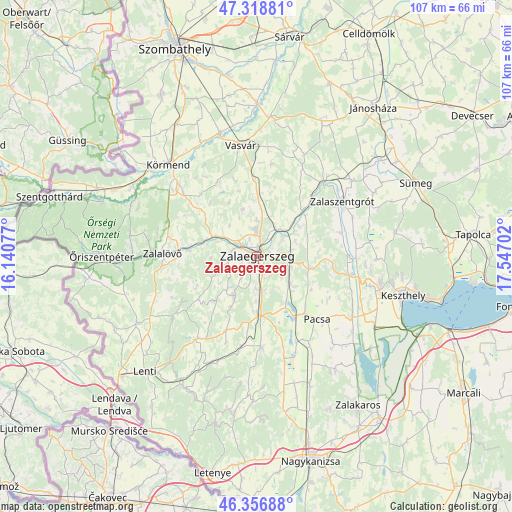
Zalaegerszeg GPS coordinates[2]
46° 50' 24" North, 16° 50' 38.004" East
| Map corner | latitude | longitude |
|---|---|---|
| Upper-left | 47.31881°, | 16.14077° |
| Center: | 46.84°, | 16.84389° |
| Lower-right: | 46.35688°, | 17.54702° |
| Map W x H: | 107×107 km | = 66.5×66.5mi |
| max Lat: | 48.46667° ⇑75.1% North |
| Zalaegerszeg: | 46.84° |
| min Lat: | ⇓24.9% South 45.79108° |
| min Long | Zalaegerszeg | max Long |
| 16.27358° | 16.84389° | 22.68096° |
| W 2.1%⇐ | ⇒97.9% E |
Elevation
Elevation of Zalaegerszeg is 152 m = 499 ft, and this is 22.3 m = 73 ft above average elevation for this country.
| Max E: |
444 m = 1457 ft | 22.3% |
| Zalaegerszeg | 152 m 499 ft | |
| Avg. | 129.7 m = 426 ft | |
Min E: |
71 m = 233 ft | 77.7% |
See also: Zalaegerszeg elevation on elevation.city.
Geographical zone
Zalaegerszeg is located in North temperate zone (between Tropic of Cancer and the Arctic Circle). Distance of this North polar circle is 2193.1 km =1362.7 mi to North.| Distance of | km | miles | from Zalaegerszeg |
|---|---|---|---|
| North Pole | 4798.9 | 2981.9 | to North |
| Arctic Circle | 2193.1 | 1362.7 | to North |
| Tropic Cancer | 2602.2 | 1616.9 | to South |
| Equator | 5208.1 | 3236.2 | to South |


Nearby cities:
15 places around Zalaegerszeg: (largest is in red/bold)
• Alsóújlak
26.7 km =16.6 mi,  1°
1°
• Cserszegtomaj
29 km =18 mi,  98°
98°
• Gyenesdiás
34.6 km =21.5 mi, 102°
• Hévíz
26.5 km =16.5 mi, 102°
• Keszthely
31.4 km =19.5 mi, 104°
• Körmend
26.2 km =16.3 mi,  316°
316°
• Lenti
33.4 km =20.8 mi,  224°
224°
• Nemesbük
23.4 km =14.5 mi, 96°
• Pacsa
18.6 km =11.6 mi,  135°
135°
• Sármellék
28.5 km =17.7 mi,  119°
119°
• Sümeg
36.6 km =22.7 mi,  65°
65°
• Türje
25.6 km =15.9 mi,  51°
51°
• Vasvár
23.5 km =14.6 mi,  351°
351°
• Zalalövő
19.5 km =12.1 mi,  272°
272°
• Zalaszentgrót
21.3 km =13.2 mi,  56°
56°
Sources, notices
• [Note1] Compared only with cities in Hungary existing in our database
• [Src1] Map data: © OpenStreetMap contributors (CC-BY-SA)
• [Src2] Other city data from geonames.org with taken over terms of usage.
• [Src3] Geographical zone / Annual Mean Temperature by Robert A. Rohde @ Wikipedia
