Vasvár geodata
Vasvár (Vas) is a populated place; located in Hungary in Europe/Budapest (GMT+2) time zone. With population of 4,613 people, there are 323 cities with bigger population in this country. Compared to other cities in Hungary, 67.2% of cities are located further ↑North; 98% of cities are located further →East and 92.6% of cities have lower elevation than Vasvár. Note1


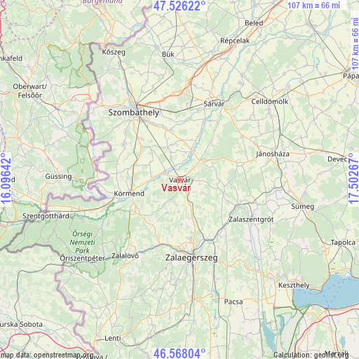
Vasvár GPS coordinates[2]
47° 2' 57.408" North, 16° 47' 58.344" East
| Map corner | latitude | longitude |
|---|---|---|
| Upper-left | 47.52622°, | 16.09642° |
| Center: | 47.04928°, | 16.79954° |
| Lower-right: | 46.56804°, | 17.50267° |
| Map W x H: | 106.5×106.5 km | = 66.2×66.2mi |
| max Lat: | 48.46667° ⇑67.2% North |
| Vasvár: | 47.04928° |
| min Lat: | ⇓32.8% South 45.79108° |
| min Long | Vasvár | max Long |
| 16.27358° | 16.79954° | 22.68096° |
| W 2%⇐ | ⇒98% E |
Elevation
Elevation of Vasvár is 202 m = 663 ft, and this is 72.3 m = 237 ft above average elevation for this country.
| Max E: |
444 m = 1457 ft | 7.4% |
| Vasvár | 202 m 663 ft | |
| Avg. | 129.7 m = 426 ft | |
Min E: |
71 m = 233 ft | 92.6% |
See also: Hungary elevation on elevation.city.
Geographical zone
Vasvár is located in North temperate zone (between Tropic of Cancer and the Arctic Circle). Distance of this North polar circle is 2169.8 km =1348.3 mi to North.| Distance of | km | miles | from Vasvár |
|---|---|---|---|
| North Pole | 4775.7 | 2967.5 | to North |
| Arctic Circle | 2169.8 | 1348.3 | to North |
| Tropic Cancer | 2625.5 | 1631.4 | to South |
| Equator | 5231.4 | 3250.6 | to South |


Nearby cities:
15 places around Vasvár: (largest is in red/bold)
• Alsóújlak
5.4 km =3.4 mi,  49°
49°
• Celldömölk
35.2 km =21.9 mi, 48°
• Gencsapáti
30.4 km =18.9 mi,  329°
329°
• Ják
19.5 km =12.1 mi,  302°
302°
• Jánosháza
28.7 km =17.8 mi,  74°
74°
• Körmend
15.3 km =9.5 mi,  253°
253°
• Nemesbük
37.1 km =23.1 mi,  134°
134°
• Szombathely
24.3 km =15.1 mi, 326°
• Sárvár
25 km =15.5 mi,  24°
24°
• Táplánszentkereszt
18 km =11.2 mi, 334°
• Türje
24.5 km =15.2 mi,  107°
107°
• Vép
21 km =13 mi,  343°
343°
• Zalaegerszeg
23.5 km =14.6 mi,  171°
171°
• Zalalövő
27.6 km =17.1 mi,  215°
215°
• Zalaszentgrót
24.2 km =15 mi,  118°
118°
Sources, notices
• [Note1] Compared only with cities in Hungary existing in our database
• [Src1] Map data: © OpenStreetMap contributors (CC-BY-SA)
• [Src2] Other city data from geonames.org with taken over terms of usage.
• [Src3] Geographical zone / Annual Mean Temperature by Robert A. Rohde @ Wikipedia
