Bogyiszló geodata
Bogyiszló (Tolna) is a populated place; located in Hungary in Europe/Budapest (GMT+2) time zone. With population of 2,348 people, there are 651 cities with bigger population in this country. Compared to other cities in Hungary, 89.4% of cities are located further ↑North; 69.8% of cities are located further →East and 86.4% of cities have higher elevation than Bogyiszló. Note1


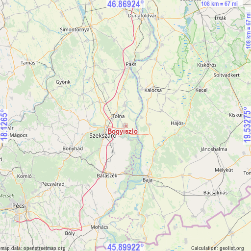
Bogyiszló GPS coordinates[2]
46° 23' 10.968" North, 18° 49' 46.632" East
| Map corner | latitude | longitude |
|---|---|---|
| Upper-left | 46.86924°, | 18.1265° |
| Center: | 46.38638°, | 18.82962° |
| Lower-right: | 45.89922°, | 19.53275° |
| Map W x H: | 107.9×107.9 km | = 67×67mi |
| max Lat: | 48.46667° ⇑89.4% North |
| Bogyiszló: | 46.38638° |
| min Lat: | ⇓10.6% South 45.79108° |
| min Long | Bogyiszló | max Long |
| 16.27358° | 18.82962° | 22.68096° |
| W 30.2%⇐ | ⇒69.8% E |
Elevation
Elevation of Bogyiszló is 89 m = 292 ft, and this is 40.7 m = 134 ft below average elevation for this country.
| Max E: |
444 m = 1457 ft | 86.4% |
| Avg. | 129.7 m = 426 ft | |
| Bogyiszló | 89 m = 292 ft | |
Min E: |
71 m = 233 ft | 13.6% |
See also: Hungary elevation on elevation.city.
Geographical zone
Bogyiszló is located in North temperate zone (between Tropic of Cancer and the Arctic Circle). Distance of this North polar circle is 2243.5 km =1394 mi to North.| Distance of | km | miles | from Bogyiszló |
|---|---|---|---|
| North Pole | 4849.4 | 3013.3 | to North |
| Arctic Circle | 2243.5 | 1394 | to North |
| Tropic Cancer | 2551.8 | 1585.6 | to South |
| Equator | 5157.7 | 3204.8 | to South |


Nearby cities:
15 places around Bogyiszló: (largest is in red/bold)
• Bátya
14.8 km =9.2 mi,  40°
40°
• Decs
12.5 km =7.8 mi,  205°
205°
• Dunaszentgyörgy
15.8 km =9.8 mi,  356°
356°
• Dusnok
10.2 km =6.3 mi,  87°
87°
• Fadd
8.8 km =5.5 mi,  354°
354°
• Kalocsa
19.4 km =12.1 mi,  34°
34°
• Nemesnádudvar
17.7 km =11 mi,  106°
106°
• Szedres
15 km =9.3 mi,  311°
311°
• Szekszárd
10.1 km =6.3 mi,  246°
246°
• Szentgálpuszta
15.7 km =9.8 mi,  265°
265°
• Sükösd
17.2 km =10.7 mi,  132°
132°
• Tengelic
18.2 km =11.3 mi,  330°
330°
• Tolna
5.8 km =3.6 mi,  321°
321°
• Érsekcsanád
19 km =11.8 mi,  141°
141°
• Őcsény
9.8 km =6.1 mi, 214°
Sources, notices
• [Note1] Compared only with cities in Hungary existing in our database
• [Src1] Map data: © OpenStreetMap contributors (CC-BY-SA)
• [Src2] Other city data from geonames.org with taken over terms of usage.
• [Src3] Geographical zone / Annual Mean Temperature by Robert A. Rohde @ Wikipedia
