Hajós geodata
Hajós (Bács-Kiskun) is a populated place; located in Hungary in Europe/Budapest (GMT+2) time zone. With population of 3,520 people, there are 411 cities with bigger population in this country. Compared to other cities in Hungary, 89% of cities are located further ↑North; 59.2% of cities are located further →East and 86.4% of cities have higher elevation than Hajós. Note1


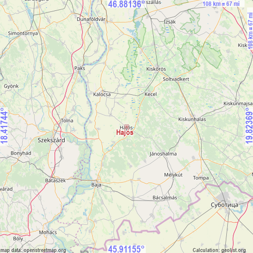
Hajós GPS coordinates[2]
46° 23' 54.996" North, 19° 7' 14.016" East
| Map corner | latitude | longitude |
|---|---|---|
| Upper-left | 46.88136°, | 18.41744° |
| Center: | 46.39861°, | 19.12056° |
| Lower-right: | 45.91155°, | 19.82369° |
| Map W x H: | 107.8×107.8 km | = 67×67mi |
| max Lat: | 48.46667° ⇑89% North |
| Hajós: | 46.39861° |
| min Lat: | ⇓11% South 45.79108° |
| min Long | Hajós | max Long |
| 16.27358° | 19.12056° | 22.68096° |
| W 40.8%⇐ | ⇒59.2% E |
Elevation
Elevation of Hajós is 89 m = 292 ft, and this is 40.7 m = 134 ft below average elevation for this country.
| Max E: |
444 m = 1457 ft | 86.4% |
| Avg. | 129.7 m = 426 ft | |
| Hajós | 89 m = 292 ft | |
Min E: |
71 m = 233 ft | 13.6% |
See also: Hungary elevation on elevation.city.
Geographical zone
Hajós is located in North temperate zone (between Tropic of Cancer and the Arctic Circle). Distance of this North polar circle is 2242.1 km =1393.2 mi to North.| Distance of | km | miles | from Hajós |
|---|---|---|---|
| North Pole | 4848 | 3012.4 | to North |
| Arctic Circle | 2242.1 | 1393.2 | to North |
| Tropic Cancer | 2553.1 | 1586.4 | to South |
| Equator | 5159 | 3205.7 | to South |


Nearby cities:
15 places around Hajós: (largest is in red/bold)
• Bogyiszló
22.4 km =13.9 mi,  266°
266°
• Bátya
16.2 km =10.1 mi,  307°
307°
• Császártöltés
5.5 km =3.4 mi,  61°
61°
• Csávoly
23.4 km =14.5 mi,  175°
175°
• Dusnok
12.1 km =7.5 mi, 265°
• Fadd
24.2 km =15 mi,  287°
287°
• Felsőszentiván
23 km =14.3 mi,  167°
167°
• Jánoshalma
19.3 km =12 mi,  125°
125°
• Kalocsa
18.5 km =11.5 mi,  322°
322°
• Kecel
17.3 km =10.7 mi,  35°
35°
• Kunfehértó
22.9 km =14.2 mi,  100°
100°
• Nemesnádudvar
8.4 km =5.2 mi,  219°
219°
• Sükösd
16.2 km =10.1 mi, 216°
• Tolna
26.1 km =16.2 mi,  276°
276°
• Érsekcsanád
19.2 km =11.9 mi,  212°
212°
Sources, notices
• [Note1] Compared only with cities in Hungary existing in our database
• [Src1] Map data: © OpenStreetMap contributors (CC-BY-SA)
• [Src2] Other city data from geonames.org with taken over terms of usage.
• [Src3] Geographical zone / Annual Mean Temperature by Robert A. Rohde @ Wikipedia
