Ráckeve geodata
Ráckeve (Pest) is a seat of a second-order administrative division; located in Hungary in Europe/Budapest (GMT+2) time zone. With population of 9,229 people, there are 177 cities with bigger population in this country. Compared to other cities in Hungary, 63.2% of cities are located further ↑North; 66.7% of cities are located further →East and 72.5% of cities have higher elevation than Ráckeve. Note1


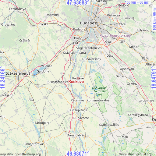
Ráckeve GPS coordinates[2]
47° 9' 39.42" North, 18° 56' 41.208" East
| Map corner | latitude | longitude |
|---|---|---|
| Upper-left | 47.63688°, | 18.24166° |
| Center: | 47.16095°, | 18.94478° |
| Lower-right: | 46.68071°, | 19.64791° |
| Map W x H: | 106.3×106.3 km | = 66.1×66.1mi |
| max Lat: | 48.46667° ⇑63.2% North |
| Ráckeve: | 47.16095° |
| min Lat: | ⇓36.8% South 45.79108° |
| min Long | Ráckeve | max Long |
| 16.27358° | 18.94478° | 22.68096° |
| W 33.3%⇐ | ⇒66.7% E |
Elevation
Elevation of Ráckeve is 100 m = 328 ft, and this is 29.7 m = 97 ft below average elevation for this country.
| Max E: |
444 m = 1457 ft | 72.5% |
| Avg. | 129.7 m = 426 ft | |
| Ráckeve | 100 m = 328 ft | |
Min E: |
71 m = 233 ft | 27.5% |
See also: Hungary elevation on elevation.city.
Geographical zone
Ráckeve is located in North temperate zone (between Tropic of Cancer and the Arctic Circle). Distance of this North polar circle is 2157.4 km =1340.5 mi to North.| Distance of | km | miles | from Ráckeve |
|---|---|---|---|
| North Pole | 4763.3 | 2959.8 | to North |
| Arctic Circle | 2157.4 | 1340.5 | to North |
| Tropic Cancer | 2637.9 | 1639.1 | to South |
| Equator | 5243.8 | 3258.3 | to South |


Nearby cities:
15 places around Ráckeve: (largest is in red/bold)
• Adony
7.6 km =4.7 mi,  232°
232°
• Bugyi
17 km =10.6 mi,  64°
64°
• Dunavarsány
16 km =9.9 mi,  35°
35°
• Délegyháza
14.2 km =8.8 mi,  50°
50°
• Dömsöd
9.3 km =5.8 mi,  147°
147°
• Ercsi
10.8 km =6.7 mi,  340°
340°
• Iváncsa
9.4 km =5.8 mi,  267°
267°
• Kiskunlacháza
5.8 km =3.6 mi, 57°
• Perkáta
17.4 km =10.8 mi,  223°
223°
• Pusztaszabolcs
13.7 km =8.5 mi,  258°
258°
• Rácalmás
15.4 km =9.6 mi,  181°
181°
• Ráckeresztúr
15.1 km =9.4 mi,  326°
326°
• Szigetcsép
11.7 km =7.3 mi,  9°
9°
• Szigetújfalu
8.2 km =5.1 mi,  350°
350°
• Tass
16.8 km =10.4 mi,  157°
157°
Sources, notices
• [Note1] Compared only with cities in Hungary existing in our database
• [Src1] Map data: © OpenStreetMap contributors (CC-BY-SA)
• [Src2] Other city data from geonames.org with taken over terms of usage.
• [Src3] Geographical zone / Annual Mean Temperature by Robert A. Rohde @ Wikipedia
