Gyöngyös geodata
Gyöngyös (Heves) is a seat of a second-order administrative division; located in Hungary in Europe/Budapest (GMT+2) time zone. With population of 32,938 people, there are 51 cities with bigger population in this country. Compared to other cities in Hungary, 76.1% of cities are located further ↓South; 60% of cities are located further ←West and 83.4% of cities have lower elevation than Gyöngyös. Note1


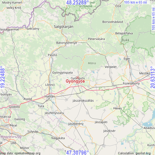
Gyöngyös GPS coordinates[2]
47° 46' 57.252" North, 19° 55' 40.8" East
| Map corner | latitude | longitude |
|---|---|---|
| Upper-left | 48.25289°, | 19.22488° |
| Center: | 47.78257°, | 19.928° |
| Lower-right: | 47.30796°, | 20.63113° |
| Map W x H: | 105.1×105.1 km | = 65.3×65.3mi |
| max Lat: | 48.46667° ⇑23.9% North |
| Gyöngyös: | 47.78257° |
| min Lat: | ⇓76.1% South 45.79108° |
| min Long | Gyöngyös | max Long |
| 16.27358° | 19.928° | 22.68096° |
| W 60%⇐ | ⇒40% E |
Elevation
Elevation of Gyöngyös is 168 m = 551 ft, and this is 38.3 m = 126 ft above average elevation for this country.
| Max E: |
444 m = 1457 ft | 16.6% |
| Gyöngyös | 168 m 551 ft | |
| Avg. | 129.7 m = 426 ft | |
Min E: |
71 m = 233 ft | 83.4% |
See also: Hungary elevation on elevation.city.
Geographical zone
Gyöngyös is located in North temperate zone (between Tropic of Cancer and the Arctic Circle). Distance of this North polar circle is 2088.3 km =1297.6 mi to North.| Distance of | km | miles | from Gyöngyös |
|---|---|---|---|
| North Pole | 4694.1 | 2916.8 | to North |
| Arctic Circle | 2088.3 | 1297.6 | to North |
| Tropic Cancer | 2707 | 1682.1 | to South |
| Equator | 5312.9 | 3301.3 | to South |


Nearby cities:
15 places around Gyöngyös: (largest is in red/bold)
• Abasár
5.8 km =3.6 mi,  74°
74°
• Adács
10.7 km =6.6 mi,  160°
160°
• Domoszló
15.2 km =9.4 mi, 68°
• Ecséd
13.3 km =8.3 mi,  245°
245°
• Gyöngyöshalász
4.6 km =2.9 mi,  179°
179°
• Gyöngyöspata
11 km =6.8 mi,  289°
289°
• Gyöngyössolymos
3.9 km =2.4 mi,  9°
9°
• Gyöngyöstarján
5.7 km =3.5 mi,  307°
307°
• Hort
14.5 km =9 mi,  225°
225°
• Jászárokszállás
16.1 km =10 mi,  165°
165°
• Karácsond
9.7 km =6 mi,  127°
127°
• Nagyréde
6.3 km =3.9 mi, 252°
• Parádsasvár
14.9 km =9.3 mi, 14°
• Rózsaszentmárton
13.9 km =8.6 mi,  269°
269°
• Vámosgyörk
10.9 km =6.8 mi, 179°
Sources, notices
• [Note1] Compared only with cities in Hungary existing in our database
• [Src1] Map data: © OpenStreetMap contributors (CC-BY-SA)
• [Src2] Other city data from geonames.org with taken over terms of usage.
• [Src3] Geographical zone / Annual Mean Temperature by Robert A. Rohde @ Wikipedia
