Gyöngyöshalász geodata
Gyöngyöshalász (Heves) is a populated place; located in Hungary in Europe/Budapest (GMT+2) time zone. With population of 2,585 people, there are 598 cities with bigger population in this country. Compared to other cities in Hungary, 74% of cities are located further ↓South; 60.1% of cities are located further ←West and 65% of cities have lower elevation than Gyöngyöshalász. Note1


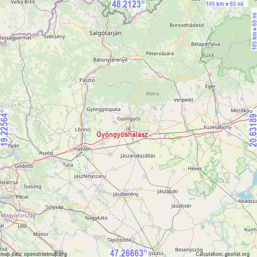
Gyöngyöshalász GPS coordinates[2]
47° 44' 29.796" North, 19° 55' 43.536" East
| Map corner | latitude | longitude |
|---|---|---|
| Upper-left | 48.2123°, | 19.22564° |
| Center: | 47.74161°, | 19.92876° |
| Lower-right: | 47.26663°, | 20.63189° |
| Map W x H: | 105.1×105.1 km | = 65.3×65.3mi |
| max Lat: | 48.46667° ⇑26% North |
| Gyöngyöshalász: | 47.74161° |
| min Lat: | ⇓74% South 45.79108° |
| min Long | Gyöngyöshalá | max Long |
| 16.27358° | 19.92876° | 22.68096° |
| W 60.1%⇐ | ⇒39.9% E |
Elevation
Elevation of Gyöngyöshalász is 131 m = 430 ft, and this is 1.3 m = 4 ft above average elevation for this country.
| Max E: |
444 m = 1457 ft | 35% |
| Gyöngyöshalász | 131 m 430 ft | |
| Avg. | 129.7 m = 426 ft | |
Min E: |
71 m = 233 ft | 65% |
See also: Hungary elevation on elevation.city.
Geographical zone
Gyöngyöshalász is located in North temperate zone (between Tropic of Cancer and the Arctic Circle). Distance of this North polar circle is 2092.8 km =1300.4 mi to North.| Distance of | km | miles | from Gyöngyöshalász |
|---|---|---|---|
| North Pole | 4698.7 | 2919.6 | to North |
| Arctic Circle | 2092.8 | 1300.4 | to North |
| Tropic Cancer | 2702.5 | 1679.3 | to South |
| Equator | 5308.4 | 3298.5 | to South |


Nearby cities:
15 places around Gyöngyöshalász: (largest is in red/bold)
• Abasár
8.3 km =5.2 mi,  42°
42°
• Adács
6.6 km =4.1 mi,  146°
146°
• Csány
12.8 km =8 mi,  215°
215°
• Domoszló
17.4 km =10.8 mi,  54°
54°
• Ecséd
12.1 km =7.5 mi,  265°
265°
• Gyöngyös
4.6 km =2.9 mi,  359°
359°
• Gyöngyöspata
13.2 km =8.2 mi,  308°
308°
• Gyöngyössolymos
8.4 km =5.2 mi,  3°
3°
• Gyöngyöstarján
9.2 km =5.7 mi,  330°
330°
• Hort
11.9 km =7.4 mi,  241°
241°
• Jászárokszállás
11.7 km =7.3 mi,  160°
160°
• Karácsond
7.7 km =4.8 mi,  99°
99°
• Nagyréde
6.6 km =4.1 mi,  293°
293°
• Rózsaszentmárton
14.7 km =9.1 mi, 287°
• Vámosgyörk
6.4 km =4 mi,  179°
179°
Sources, notices
• [Note1] Compared only with cities in Hungary existing in our database
• [Src1] Map data: © OpenStreetMap contributors (CC-BY-SA)
• [Src2] Other city data from geonames.org with taken over terms of usage.
• [Src3] Geographical zone / Annual Mean Temperature by Robert A. Rohde @ Wikipedia
