Tiszaalpár geodata
Tiszaalpár (Bács-Kiskun) is a populated place; located in Hungary in Europe/Budapest (GMT+2) time zone. With population of 5,070 people, there are 295 cities with bigger population in this country. Compared to other cities in Hungary, 76.2% of cities are located further ↑North; 61.9% of cities are located further ←West and 89.4% of cities have higher elevation than Tiszaalpár. Note1


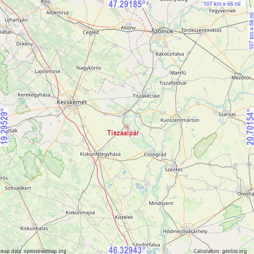
Tiszaalpár GPS coordinates[2]
46° 48' 46.044" North, 19° 59' 54.276" East
| Map corner | latitude | longitude |
|---|---|---|
| Upper-left | 47.29185°, | 19.29529° |
| Center: | 46.81279°, | 19.99841° |
| Lower-right: | 46.32943°, | 20.70154° |
| Map W x H: | 107×107 km | = 66.5×66.5mi |
| max Lat: | 48.46667° ⇑76.2% North |
| Tiszaalpár: | 46.81279° |
| min Lat: | ⇓23.8% South 45.79108° |
| min Long | Tiszaalpár | max Long |
| 16.27358° | 19.99841° | 22.68096° |
| W 61.9%⇐ | ⇒38.1% E |
Elevation
Elevation of Tiszaalpár is 87 m = 285 ft, and this is 42.7 m = 140 ft below average elevation for this country.
| Max E: |
444 m = 1457 ft | 89.4% |
| Avg. | 129.7 m = 426 ft | |
| Tiszaalpár | 87 m = 285 ft | |
Min E: |
71 m = 233 ft | 10.6% |
See also: Hungary elevation on elevation.city.
Geographical zone
Tiszaalpár is located in North temperate zone (between Tropic of Cancer and the Arctic Circle). Distance of this North polar circle is 2196.1 km =1364.6 mi to North.| Distance of | km | miles | from Tiszaalpár |
|---|---|---|---|
| North Pole | 4802 | 2983.8 | to North |
| Arctic Circle | 2196.1 | 1364.6 | to North |
| Tropic Cancer | 2599.2 | 1615.1 | to South |
| Equator | 5205.1 | 3234.3 | to South |


Nearby cities:
15 places around Tiszaalpár: (largest is in red/bold)
• Cibakháza
22.3 km =13.9 mi,  42°
42°
• Cserkeszőlő
15.4 km =9.6 mi,  68°
68°
• Csongrád
15.6 km =9.7 mi,  135°
135°
• Fülöpjakab
22.5 km =14 mi,  249°
249°
• Kiskunfélegyháza
16.2 km =10.1 mi,  226°
226°
• Kocsér
21.8 km =13.5 mi,  344°
344°
• Kunszentmárton
22.3 km =13.9 mi,  82°
82°
• Lakitelek
7 km =4.3 mi,  357°
357°
• Nyárlőrinc
10.5 km =6.5 mi,  299°
299°
• Pálmonostora
21.3 km =13.2 mi,  189°
189°
• Szelevény
15.6 km =9.7 mi,  94°
94°
• Szentkirály
13.3 km =8.3 mi,  332°
332°
• Tiszakécske
15.5 km =9.6 mi,  30°
30°
• Tömörkény
22 km =13.7 mi,  171°
171°
• Városföld
18.4 km =11.4 mi,  271°
271°
Sources, notices
• [Note1] Compared only with cities in Hungary existing in our database
• [Src1] Map data: © OpenStreetMap contributors (CC-BY-SA)
• [Src2] Other city data from geonames.org with taken over terms of usage.
• [Src3] Geographical zone / Annual Mean Temperature by Robert A. Rohde @ Wikipedia
