Uluale geodata
Uluale (South Sulawesi) is a seat of a third-order administrative division; located in Indonesia in Asia/Makassar (GMT+8) time zone. In our database, there are 407 cities with bigger population. Compared to other cities in Indonesia, 89.6% of cities are located further ↓South; 82.2% of cities are located further ←West and 70.2% of cities have higher elevation than Uluale. Note1


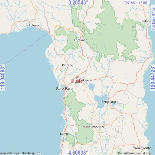
Uluale GPS coordinates[2]
3° 54' 25.92" South, 119° 44' 38.76" East
| Map corner | latitude | longitude |
|---|---|---|
| Upper-left | -3.20543°, | 119.04098° |
| Center: | -3.9072°, | 119.7441° |
| Lower-right: | -4.60838°, | 120.44723° |
| Map W x H: | 156×156 km | = 96.9×96.9mi |
| max Lat: | 5.88969° ⇑10.4% North |
| Uluale: | -3.9072° |
| min Lat: | ⇓89.6% South -10.934° |
| min Long | Uluale | max Long |
| 95.1345° | 119.7441° | 140.9419° |
| W 82.2%⇐ | ⇒17.8% E |
Elevation
Elevation of Uluale is 32 m = 105 ft, and this is 197.7 m = 649 ft below average elevation for this country.
| Max E: |
3185 m = 10449 ft | 70.2% |
| Avg. | 229.7 m = 754 ft | |
| Uluale | 32 m = 105 ft | |
Min E: |
-1 m = -3 ft | 29.8% |
See also: Indonesia elevation on elevation.city.
Geographical zone
Uluale is located in South Torrid zone (between Equator and Tropic of Capricorn). Distance of Equator is 434.4 km =269.9 mi to North.| Distance of | km | miles | from Uluale |
|---|---|---|---|
| Equator | 434.4 | 269.9 | to North |
| Tropic Capricorn | 2171.5 | 1349.3 | to South |
| Antarctic Circle | 6966.7 | 4328.9 | to South |
| South Pole | 9572.6 | 5948.1 | to South |


Nearby cities:
15 places around Uluale: (largest is in red/bold)
• Amparita
12.2 km =7.6 mi,  141°
141°
• Baranti
8.7 km =5.4 mi,  30°
30°
• Cempa Pasar
25 km =15.5 mi,  314°
314°
• Enrekang
38.2 km =23.7 mi,  4°
4°
• Harapankarya
14.4 km =8.9 mi,  230°
230°
• Lampa
35.8 km =22.2 mi,  319°
319°
• Langnga
25.5 km =15.8 mi,  285°
285°
• Majennang
16.7 km =10.4 mi,  244°
244°
• Parepare
17.7 km =11 mi, 228°
• Pinrang
16.9 km =10.5 mi, 322°
• Rappang
10.7 km =6.6 mi,  49°
49°
• Sengkang
40.1 km =24.9 mi,  127°
127°
• Sidenreng
6.5 km =4 mi,  110°
110°
• Tancung
35.5 km =22.1 mi,  117°
117°
• Teppo
23.8 km =14.8 mi,  339°
339°
Sources, notices
• [Note1] Compared only with cities in Indonesia existing in our database
• [Src1] Map data: © OpenStreetMap contributors (CC-BY-SA)
• [Src2] Other city data from geonames.org with taken over terms of usage.
• [Src3] Geographical zone / Annual Mean Temperature by Robert A. Rohde @ Wikipedia
