Parepare geodata
Parepare (South Sulawesi) is a populated place; located in Indonesia in Asia/Makassar (GMT+8) time zone. With population of 140,000 people, there are 84 cities with bigger population in this country. Compared to other cities in Indonesia, 89.4% of cities are located further ↓South; 82.1% of cities are located further ←West and 77.1% of cities have higher elevation than Parepare. Note1


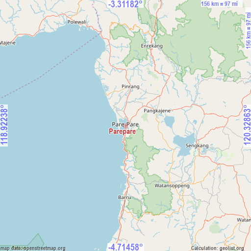
Parepare GPS coordinates[2]
4° 0' 48.6" South, 119° 37' 31.8" East
| Map corner | latitude | longitude |
|---|---|---|
| Upper-left | -3.31182°, | 118.92238° |
| Center: | -4.0135°, | 119.6255° |
| Lower-right: | -4.71458°, | 120.32863° |
| Map W x H: | 156×156 km | = 96.9×96.9mi |
| max Lat: | 5.88969° ⇑10.6% North |
| Parepare: | -4.0135° |
| min Lat: | ⇓89.4% South -10.934° |
| min Long | Parepare | max Long |
| 95.1345° | 119.6255° | 140.9419° |
| W 82.1%⇐ | ⇒17.9% E |
Elevation
Elevation of Parepare is 22 m = 72 ft, and this is 207.7 m = 681 ft below average elevation for this country.
| Max E: |
3185 m = 10449 ft | 77.1% |
| Avg. | 229.7 m = 754 ft | |
| Parepare | 22 m = 72 ft | |
Min E: |
-1 m = -3 ft | 22.9% |
See also: Parepare elevation on elevation.city.
Geographical zone
Parepare is located in South Torrid zone (between Equator and Tropic of Capricorn). Distance of Equator is 446.3 km =277.3 mi to North.| Distance of | km | miles | from Parepare |
|---|---|---|---|
| Equator | 446.3 | 277.3 | to North |
| Tropic Capricorn | 2159.7 | 1342 | to South |
| Antarctic Circle | 6954.9 | 4321.6 | to South |
| South Pole | 9560.8 | 5940.8 | to South |


Nearby cities:
15 places around Parepare: (largest is in red/bold)
• Amparita
20.8 km =12.9 mi,  83°
83°
• Baranti
26.1 km =16.2 mi,  42°
42°
• Barru
44.3 km =27.5 mi,  181°
181°
• Cempa Pasar
29.8 km =18.5 mi,  351°
351°
• Harapankarya
3.4 km =2.1 mi, 37°
• Lampa
40.2 km =25 mi, 345°
• Langnga
21.9 km =13.6 mi,  328°
328°
• Majennang
4.9 km =3 mi,  338°
338°
• Pinrang
25.5 km =15.8 mi,  6°
6°
• Rappang
28.4 km =17.6 mi,  48°
48°
• Sengkang
46.6 km =29 mi,  105°
105°
• Sidenreng
21.5 km =13.4 mi,  63°
63°
• Tancung
44.9 km =27.9 mi,  95°
95°
• Teppo
34.5 km =21.4 mi, 8°
• Uluale
17.7 km =11 mi, 48°
Sources, notices
• [Note1] Compared only with cities in Indonesia existing in our database
• [Src1] Map data: © OpenStreetMap contributors (CC-BY-SA)
• [Src2] Other city data from geonames.org with taken over terms of usage.
• [Src3] Geographical zone / Annual Mean Temperature by Robert A. Rohde @ Wikipedia
