Harapankarya geodata
Harapankarya (South Sulawesi) is a seat of a third-order administrative division; located in Indonesia in Asia/Makassar (GMT+8) time zone. In our database, there are 407 cities with bigger population. Compared to other cities in Indonesia, 89.4% of cities are located further ↓South; 82.1% of cities are located further ←West and 70.7% of cities have higher elevation than Harapankarya. Note1


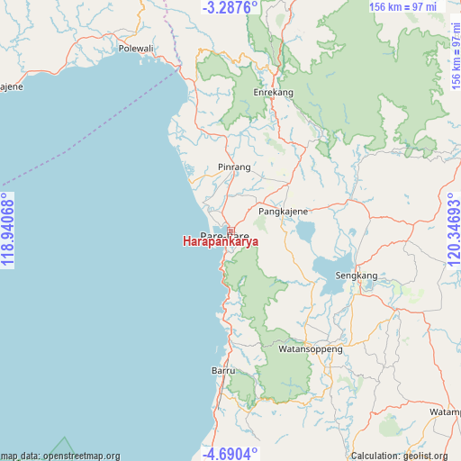
Harapankarya GPS coordinates[2]
3° 59' 21.48" South, 119° 38' 37.68" East
| Map corner | latitude | longitude |
|---|---|---|
| Upper-left | -3.2876°, | 118.94068° |
| Center: | -3.9893°, | 119.6438° |
| Lower-right: | -4.6904°, | 120.34693° |
| Map W x H: | 156×156 km | = 96.9×96.9mi |
| max Lat: | 5.88969° ⇑10.6% North |
| Harapankarya: | -3.9893° |
| min Lat: | ⇓89.4% South -10.934° |
| min Long | Harapankarya | max Long |
| 95.1345° | 119.6438° | 140.9419° |
| W 82.1%⇐ | ⇒17.9% E |
Elevation
Elevation of Harapankarya is 31 m = 102 ft, and this is 198.7 m = 652 ft below average elevation for this country.
| Max E: |
3185 m = 10449 ft | 70.7% |
| Avg. | 229.7 m = 754 ft | |
| Harapankarya | 31 m = 102 ft | |
Min E: |
-1 m = -3 ft | 29.3% |
See also: Indonesia elevation on elevation.city.
Geographical zone
Harapankarya is located in South Torrid zone (between Equator and Tropic of Capricorn). Distance of Equator is 443.6 km =275.6 mi to North.| Distance of | km | miles | from Harapankarya |
|---|---|---|---|
| Equator | 443.6 | 275.6 | to North |
| Tropic Capricorn | 2162.4 | 1343.7 | to South |
| Antarctic Circle | 6957.6 | 4323.3 | to South |
| South Pole | 9563.5 | 5942.5 | to South |


Nearby cities:
15 places around Harapankarya: (largest is in red/bold)
• Amparita
18.7 km =11.6 mi,  91°
91°
• Baranti
22.7 km =14.1 mi,  43°
43°
• Barru
47.1 km =29.3 mi,  183°
183°
• Cempa Pasar
27.6 km =17.1 mi,  346°
346°
• Lampa
38.3 km =23.8 mi,  341°
341°
• Langnga
20.9 km =13 mi,  319°
319°
• Majennang
4.3 km =2.7 mi,  295°
295°
• Parepare
3.4 km =2.1 mi,  217°
217°
• Pinrang
22.6 km =14 mi,  2°
2°
• Rappang
25.1 km =15.6 mi,  50°
50°
• Sengkang
45.5 km =28.3 mi,  109°
109°
• Sidenreng
18.6 km =11.6 mi,  68°
68°
• Tancung
43.3 km =26.9 mi,  99°
99°
• Teppo
31.6 km =19.6 mi,  5°
5°
• Uluale
14.4 km =8.9 mi, 50°
Sources, notices
• [Note1] Compared only with cities in Indonesia existing in our database
• [Src1] Map data: © OpenStreetMap contributors (CC-BY-SA)
• [Src2] Other city data from geonames.org with taken over terms of usage.
• [Src3] Geographical zone / Annual Mean Temperature by Robert A. Rohde @ Wikipedia
