Sidenreng geodata
Sidenreng (South Sulawesi) is a seat of a second-order administrative division; located in Indonesia in Asia/Makassar (GMT+8) time zone. In our database, there are 407 cities with bigger population. Compared to other cities in Indonesia, 89.6% of cities are located further ↓South; 82.3% of cities are located further ←West and 77.1% of cities have higher elevation than Sidenreng. Note1


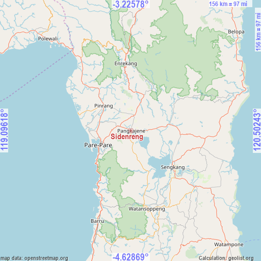
Sidenreng GPS coordinates[2]
3° 55' 39.108" South, 119° 47' 57.48" East
| Map corner | latitude | longitude |
|---|---|---|
| Upper-left | -3.22578°, | 119.09618° |
| Center: | -3.92753°, | 119.7993° |
| Lower-right: | -4.62869°, | 120.50243° |
| Map W x H: | 156×156 km | = 96.9×96.9mi |
| max Lat: | 5.88969° ⇑10.4% North |
| Sidenreng: | -3.92753° |
| min Lat: | ⇓89.6% South -10.934° |
| min Long | Sidenreng | max Long |
| 95.1345° | 119.7993° | 140.9419° |
| W 82.3%⇐ | ⇒17.7% E |
Elevation
Elevation of Sidenreng is 22 m = 72 ft, and this is 207.7 m = 681 ft below average elevation for this country.
| Max E: |
3185 m = 10449 ft | 77.1% |
| Avg. | 229.7 m = 754 ft | |
| Sidenreng | 22 m = 72 ft | |
Min E: |
-1 m = -3 ft | 22.9% |
See also: Indonesia elevation on elevation.city.
Geographical zone
Sidenreng is located in South Torrid zone (between Equator and Tropic of Capricorn). Distance of Equator is 436.7 km =271.4 mi to North.| Distance of | km | miles | from Sidenreng |
|---|---|---|---|
| Equator | 436.7 | 271.4 | to North |
| Tropic Capricorn | 2169.2 | 1347.9 | to South |
| Antarctic Circle | 6964.5 | 4327.5 | to South |
| South Pole | 9570.4 | 5946.8 | to South |


Nearby cities:
15 places around Sidenreng: (largest is in red/bold)
• Amparita
7.5 km =4.7 mi,  168°
168°
• Baranti
9.9 km =6.2 mi,  350°
350°
• Cempa Pasar
31.1 km =19.3 mi,  309°
309°
• Enrekang
40.4 km =25.1 mi,  355°
355°
• Harapankarya
18.6 km =11.6 mi,  248°
248°
• Kotabaru
39.5 km =24.5 mi,  143°
143°
• Langnga
32.1 km =19.9 mi,  286°
286°
• Majennang
21.7 km =13.5 mi,  256°
256°
• Parepare
21.5 km =13.4 mi,  243°
243°
• Pinrang
22.7 km =14.1 mi, 313°
• Rappang
9.4 km =5.8 mi,  12°
12°
• Sengkang
33.9 km =21.1 mi,  131°
131°
• Tancung
29 km =18 mi,  118°
118°
• Teppo
28.5 km =17.7 mi,  329°
329°
• Uluale
6.5 km =4 mi, 290°
Sources, notices
• [Note1] Compared only with cities in Indonesia existing in our database
• [Src1] Map data: © OpenStreetMap contributors (CC-BY-SA)
• [Src2] Other city data from geonames.org with taken over terms of usage.
• [Src3] Geographical zone / Annual Mean Temperature by Robert A. Rohde @ Wikipedia
