Kijang geodata
Kijang (Riau Islands) is a populated place; located in Indonesia in Asia/Jakarta (GMT+7) time zone. With population of 41,344 people, there are 265 cities with bigger population in this country. Compared to other cities in Indonesia, 96% of cities are located further ↓South; 94.8% of cities are located further →East and 97.2% of cities have higher elevation than Kijang. Note1


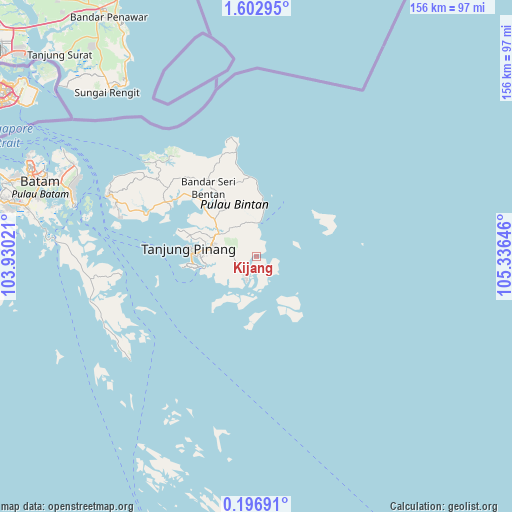
Kijang GPS coordinates[2]
0° 54' 0" North, 104° 37' 59.988" East
| Map corner | latitude | longitude |
|---|---|---|
| Upper-left | 1.60295°, | 103.93021° |
| Center: | 0.9°, | 104.63333° |
| Lower-right: | 0.19691°, | 105.33646° |
| Map W x H: | 156.3×156.3 km | = 97.1×97.1mi |
| max Lat: | 5.88969° ⇑4% North |
| Kijang: | 0.9° |
| min Lat: | ⇓96% South -10.934° |
| min Long | Kijang | max Long |
| 95.1345° | 104.63333° | 140.9419° |
| W 5.2%⇐ | ⇒94.8% E |
Elevation
Elevation of Kijang is 6 m = 20 ft, and this is 223.7 m = 734 ft below average elevation for this country.
| Max E: |
3185 m = 10449 ft | 97.2% |
| Avg. | 229.7 m = 754 ft | |
| Kijang | 6 m = 20 ft | |
Min E: |
-1 m = -3 ft | 2.8% |
See also: Kijang elevation on elevation.city.
Geographical zone
Kijang is located in North Torrid zone (between Equator and Tropic of Cancer). Distance of Equator is 100.1 km =62.2 mi to South.| Distance of | km | miles | from Kijang |
|---|---|---|---|
| North Pole | 9907 | 6155.9 | to North |
| Arctic Circle | 7301.1 | 4536.7 | to North |
| Tropic Cancer | 2505.8 | 1557 | to North |
| Equator | 100.1 | 62.2 | to South |


Nearby cities:
15 places around Kijang: (largest is in red/bold)
• Bandar Seri Bentan
24.2 km =15 mi,  315°
315°
• Batam
73.1 km =45.4 mi,  292°
292°
• Belakangpadang
87 km =54.1 mi, 288°
• Daik Lingga
123.9 km =77 mi,  180°
180°
• Meral
138.2 km =85.9 mi,  274°
274°
• Moro
104.1 km =64.7 mi,  261°
261°
• Pancur Biru Lestari II
65.9 km =40.9 mi,  282°
282°
• Pasirpanjang
144.9 km =90 mi, 279°
• Sawang
143.1 km =88.9 mi, 262°
• Sekupang
82.5 km =51.3 mi, 287°
• Senayang
95.9 km =59.6 mi, 178°
• Tanjung Pinang
19.5 km =12.1 mi, 275°
• Tanjungbatu
133 km =82.6 mi, 258°
• Tebing
135.6 km =84.3 mi, 276°
• Urung
128.5 km =79.8 mi, 264°
Sources, notices
• [Note1] Compared only with cities in Indonesia existing in our database
• [Src1] Map data: © OpenStreetMap contributors (CC-BY-SA)
• [Src2] Other city data from geonames.org with taken over terms of usage.
• [Src3] Geographical zone / Annual Mean Temperature by Robert A. Rohde @ Wikipedia
