Amahusu geodata
Amahusu (Maluku) is a seat of a third-order administrative division; located in Indonesia in Asia/Jayapura (GMT+9) time zone. In our database, there are 407 cities with bigger population. Compared to other cities in Indonesia, 89.9% of cities are located further ↓South; 98.5% of cities are located further ←West and 78.1% of cities have higher elevation than Amahusu. Note1


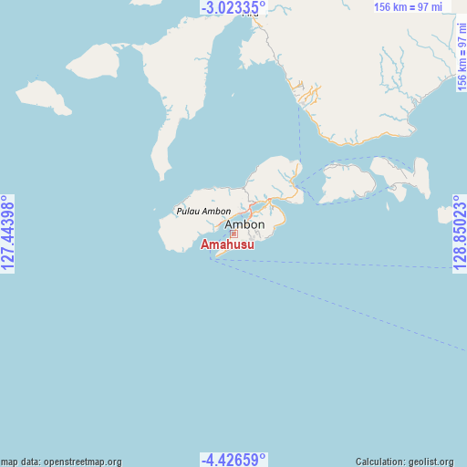
Amahusu GPS coordinates[2]
3° 43' 30.9" South, 128° 8' 49.56" East
| Map corner | latitude | longitude |
|---|---|---|
| Upper-left | -3.02335°, | 127.44398° |
| Center: | -3.72525°, | 128.1471° |
| Lower-right: | -4.42659°, | 128.85023° |
| Map W x H: | 156×156 km | = 96.9×96.9mi |
| max Lat: | 5.88969° ⇑10.1% North |
| Amahusu: | -3.72525° |
| min Lat: | ⇓89.9% South -10.934° |
| min Long | Amahusu | max Long |
| 95.1345° | 128.1471° | 140.9419° |
| W 98.5%⇐ | ⇒1.5% E |
Elevation
Elevation of Amahusu is 21 m = 69 ft, and this is 208.7 m = 685 ft below average elevation for this country.
| Max E: |
3185 m = 10449 ft | 78.1% |
| Avg. | 229.7 m = 754 ft | |
| Amahusu | 21 m = 69 ft | |
Min E: |
-1 m = -3 ft | 21.9% |
See also: Indonesia elevation on elevation.city.
Geographical zone
Amahusu is located in South Torrid zone (between Equator and Tropic of Capricorn). Distance of Equator is 414.2 km =257.4 mi to North.| Distance of | km | miles | from Amahusu |
|---|---|---|---|
| Equator | 414.2 | 257.4 | to North |
| Tropic Capricorn | 2191.7 | 1361.9 | to South |
| Antarctic Circle | 6987 | 4341.5 | to South |
| South Pole | 9592.9 | 5960.7 | to South |


Nearby cities:
15 places around Amahusu: (largest is in red/bold)
• Amahai
95.9 km =59.6 mi,  63°
63°
• Ambon
5.2 km =3.2 mi,  50°
50°
• Hila
16.7 km =10.4 mi,  336°
336°
• Kairatu
48.3 km =30 mi,  30°
30°
• Masohi
102.8 km =63.9 mi, 62°
• Namlea
127.8 km =79.4 mi,  293°
293°
• Namrole
158.2 km =98.3 mi,  265°
265°
• Passo
15.8 km =9.8 mi, 47°
• Pelau
42.3 km =26.3 mi, 57°
• Piru
74 km =46 mi,  4°
4°
• Saparua
58.6 km =36.4 mi,  73°
73°
• Taniwel
103.7 km =64.4 mi,  20°
20°
• Tehoru
158.1 km =98.2 mi,  78°
78°
• Tulehu
25.2 km =15.7 mi, 52°
• Waipia
103 km =64 mi, 54°
Sources, notices
• [Note1] Compared only with cities in Indonesia existing in our database
• [Src1] Map data: © OpenStreetMap contributors (CC-BY-SA)
• [Src2] Other city data from geonames.org with taken over terms of usage.
• [Src3] Geographical zone / Annual Mean Temperature by Robert A. Rohde @ Wikipedia
