Saparua geodata
Saparua (Maluku) is a seat of a third-order administrative division; located in Indonesia in Asia/Jayapura (GMT+9) time zone. In our database, there are 407 cities with bigger population. Compared to other cities in Indonesia, 90.2% of cities are located further ↓South; 98.6% of cities are located further ←West and 99.4% of cities have higher elevation than Saparua. Note1


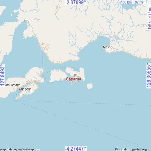
Saparua GPS coordinates[2]
3° 34' 22.8" South, 128° 39' 8.712" East
| Map corner | latitude | longitude |
|---|---|---|
| Upper-left | -2.87099°, | 127.9493° |
| Center: | -3.573°, | 128.65242° |
| Lower-right: | -4.27447°, | 129.35555° |
| Map W x H: | 156.1×156.1 km | = 97×97mi |
| max Lat: | 5.88969° ⇑9.8% North |
| Saparua: | -3.573° |
| min Lat: | ⇓90.2% South -10.934° |
| min Long | Saparua | max Long |
| 95.1345° | 128.65242° | 140.9419° |
| W 98.6%⇐ | ⇒1.4% E |
Elevation
Elevation of Saparua is 3 m = 10 ft, and this is 226.7 m = 744 ft below average elevation for this country.
| Max E: |
3185 m = 10449 ft | 99.4% |
| Avg. | 229.7 m = 754 ft | |
| Saparua | 3 m = 10 ft | |
Min E: |
-1 m = -3 ft | 0.6% |
See also: Indonesia elevation on elevation.city.
Geographical zone
Saparua is located in South Torrid zone (between Equator and Tropic of Capricorn). Distance of Equator is 397.3 km =246.9 mi to North.| Distance of | km | miles | from Saparua |
|---|---|---|---|
| Equator | 397.3 | 246.9 | to North |
| Tropic Capricorn | 2208.6 | 1372.4 | to South |
| Antarctic Circle | 7003.9 | 4352 | to South |
| South Pole | 9609.8 | 5971.3 | to South |


Nearby cities:
15 places around Saparua: (largest is in red/bold)
• Amahai
39.4 km =24.5 mi,  48°
48°
• Amahusu
58.6 km =36.4 mi,  253°
253°
• Ambon
53.8 km =33.4 mi,  255°
255°
• Hila
62.7 km =39 mi,  268°
268°
• Kairatu
40 km =24.9 mi,  307°
307°
• Masohi
46.5 km =28.9 mi, 48°
• Passo
44.8 km =27.8 mi, 261°
• Pelau
21.3 km =13.2 mi,  285°
285°
• Piru
76.3 km =47.4 mi,  318°
318°
• Taniwel
82.4 km =51.2 mi,  346°
346°
• Tehoru
99.9 km =62.1 mi,  81°
81°
• Tulehu
36.1 km =22.4 mi, 267°
• Wahai
130.9 km =81.3 mi, 48°
• Waipia
51.1 km =31.8 mi,  32°
32°
• Werinama
162 km =100.7 mi,  87°
87°
Sources, notices
• [Note1] Compared only with cities in Indonesia existing in our database
• [Src1] Map data: © OpenStreetMap contributors (CC-BY-SA)
• [Src2] Other city data from geonames.org with taken over terms of usage.
• [Src3] Geographical zone / Annual Mean Temperature by Robert A. Rohde @ Wikipedia
