Masohi geodata
Masohi (Maluku) is a seat of a second-order administrative division; located in Indonesia in Asia/Jayapura (GMT+9) time zone. In our database, there are 407 cities with bigger population. Compared to other cities in Indonesia, 90.7% of cities are located further ↓South; 98.6% of cities are located further ←West and 78.1% of cities have higher elevation than Masohi. Note1


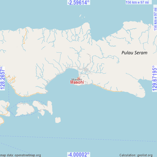
Masohi GPS coordinates[2]
3° 17' 53.988" South, 128° 58' 7.752" East
| Map corner | latitude | longitude |
|---|---|---|
| Upper-left | -2.59614°, | 128.2657° |
| Center: | -3.29833°, | 128.96882° |
| Lower-right: | -4.00002°, | 129.67195° |
| Map W x H: | 156.1×156.1 km | = 97×97mi |
| max Lat: | 5.88969° ⇑9.3% North |
| Masohi: | -3.29833° |
| min Lat: | ⇓90.7% South -10.934° |
| min Long | Masohi | max Long |
| 95.1345° | 128.96882° | 140.9419° |
| W 98.6%⇐ | ⇒1.4% E |
Elevation
Elevation of Masohi is 21 m = 69 ft, and this is 208.7 m = 685 ft below average elevation for this country.
| Max E: |
3185 m = 10449 ft | 78.1% |
| Avg. | 229.7 m = 754 ft | |
| Masohi | 21 m = 69 ft | |
Min E: |
-1 m = -3 ft | 21.9% |
See also: Indonesia elevation on elevation.city.
Geographical zone
Masohi is located in South Torrid zone (between Equator and Tropic of Capricorn). Distance of Equator is 366.7 km =227.9 mi to North.| Distance of | km | miles | from Masohi |
|---|---|---|---|
| Equator | 366.7 | 227.9 | to North |
| Tropic Capricorn | 2239.2 | 1391.4 | to South |
| Antarctic Circle | 7034.4 | 4371 | to South |
| South Pole | 9640.3 | 5990.2 | to South |


Nearby cities:
15 places around Masohi: (largest is in red/bold)
• Amahai
7.1 km =4.4 mi,  229°
229°
• Amahusu
102.8 km =63.9 mi,  242°
242°
• Ambon
97.7 km =60.7 mi, 243°
• Hila
102.9 km =63.9 mi,  251°
251°
• Kairatu
66.9 km =41.6 mi,  264°
264°
• Passo
87.7 km =54.5 mi, 245°
• Pelau
60.8 km =37.8 mi, 246°
• Piru
89.9 km =55.9 mi,  287°
287°
• Saparua
46.5 km =28.9 mi, 228°
• Taniwel
73.7 km =45.8 mi,  312°
312°
• Tehoru
65.8 km =40.9 mi,  104°
104°
• Tulehu
78.2 km =48.6 mi, 245°
• Wahai
84.4 km =52.4 mi,  48°
48°
• Waipia
14.3 km =8.9 mi,  329°
329°
• Werinama
128.7 km =80 mi, 100°
Sources, notices
• [Note1] Compared only with cities in Indonesia existing in our database
• [Src1] Map data: © OpenStreetMap contributors (CC-BY-SA)
• [Src2] Other city data from geonames.org with taken over terms of usage.
• [Src3] Geographical zone / Annual Mean Temperature by Robert A. Rohde @ Wikipedia
