Amahai geodata
Amahai (Maluku) is a populated place; located in Indonesia in Asia/Jayapura (GMT+9) time zone. With population of 47,653 people, there are 244 cities with bigger population in this country. Compared to other cities in Indonesia, 90.7% of cities are located further ↓South; 98.6% of cities are located further ←West and 97.2% of cities have higher elevation than Amahai. Note1


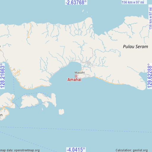
Amahai GPS coordinates[2]
3° 20' 23.424" South, 128° 55' 11.1" East
| Map corner | latitude | longitude |
|---|---|---|
| Upper-left | -2.63768°, | 128.21663° |
| Center: | -3.33984°, | 128.91975° |
| Lower-right: | -4.0415°, | 129.62288° |
| Map W x H: | 156.1×156.1 km | = 97×97mi |
| max Lat: | 5.88969° ⇑9.3% North |
| Amahai: | -3.33984° |
| min Lat: | ⇓90.7% South -10.934° |
| min Long | Amahai | max Long |
| 95.1345° | 128.91975° | 140.9419° |
| W 98.6%⇐ | ⇒1.4% E |
Elevation
Elevation of Amahai is 6 m = 20 ft, and this is 223.7 m = 734 ft below average elevation for this country.
| Max E: |
3185 m = 10449 ft | 97.2% |
| Avg. | 229.7 m = 754 ft | |
| Amahai | 6 m = 20 ft | |
Min E: |
-1 m = -3 ft | 2.8% |
See also: Amahai elevation on elevation.city.
Geographical zone
Amahai is located in South Torrid zone (between Equator and Tropic of Capricorn). Distance of Equator is 371.4 km =230.8 mi to North.| Distance of | km | miles | from Amahai |
|---|---|---|---|
| Equator | 371.4 | 230.8 | to North |
| Tropic Capricorn | 2234.6 | 1388.5 | to South |
| Antarctic Circle | 7029.8 | 4368.1 | to South |
| South Pole | 9635.7 | 5987.3 | to South |


Nearby cities:
15 places around Amahai: (largest is in red/bold)
• Amahusu
95.9 km =59.6 mi,  243°
243°
• Ambon
90.8 km =56.4 mi, 244°
• Hila
96.3 km =59.8 mi,  253°
253°
• Kairatu
61.2 km =38 mi,  268°
268°
• Masohi
7.1 km =4.4 mi,  49°
49°
• Passo
80.8 km =50.2 mi, 246°
• Pelau
54 km =33.6 mi, 248°
• Piru
86.2 km =53.6 mi,  291°
291°
• Saparua
39.4 km =24.5 mi,  228°
228°
• Taniwel
73.2 km =45.5 mi,  317°
317°
• Tehoru
70.2 km =43.6 mi,  99°
99°
• Tulehu
71.3 km =44.3 mi, 247°
• Wahai
91.5 km =56.9 mi, 48°
• Waipia
17 km =10.6 mi,  353°
353°
• Werinama
133.4 km =82.9 mi, 97°
Sources, notices
• [Note1] Compared only with cities in Indonesia existing in our database
• [Src1] Map data: © OpenStreetMap contributors (CC-BY-SA)
• [Src2] Other city data from geonames.org with taken over terms of usage.
• [Src3] Geographical zone / Annual Mean Temperature by Robert A. Rohde @ Wikipedia
