Namlea geodata
Namlea (Maluku) is a seat of a second-order administrative division; located in Indonesia in Asia/Jayapura (GMT+9) time zone. In our database, there are 407 cities with bigger population. Compared to other cities in Indonesia, 90.8% of cities are located further ↓South; 98.3% of cities are located further ←West and 68.9% of cities have higher elevation than Namlea. Note1


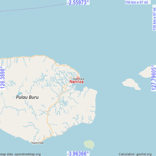
Namlea GPS coordinates[2]
3° 15' 42.984" South, 127° 5' 34.512" East
| Map corner | latitude | longitude |
|---|---|---|
| Upper-left | -2.55973°, | 126.3898° |
| Center: | -3.26194°, | 127.09292° |
| Lower-right: | -3.96366°, | 127.79605° |
| Map W x H: | 156.1×156.1 km | = 97×97mi |
| max Lat: | 5.88969° ⇑9.2% North |
| Namlea: | -3.26194° |
| min Lat: | ⇓90.8% South -10.934° |
| min Long | Namlea | max Long |
| 95.1345° | 127.09292° | 140.9419° |
| W 98.3%⇐ | ⇒1.7% E |
Elevation
Elevation of Namlea is 34 m = 112 ft, and this is 195.7 m = 642 ft below average elevation for this country.
| Max E: |
3185 m = 10449 ft | 68.9% |
| Avg. | 229.7 m = 754 ft | |
| Namlea | 34 m = 112 ft | |
Min E: |
-1 m = -3 ft | 31.1% |
See also: Indonesia elevation on elevation.city.
Geographical zone
Namlea is located in South Torrid zone (between Equator and Tropic of Capricorn). Distance of Equator is 362.7 km =225.4 mi to North.| Distance of | km | miles | from Namlea |
|---|---|---|---|
| Equator | 362.7 | 225.4 | to North |
| Tropic Capricorn | 2243.2 | 1393.9 | to South |
| Antarctic Circle | 7038.5 | 4373.5 | to South |
| South Pole | 9644.4 | 5992.8 | to South |


Nearby cities:
15 places around Namlea: (largest is in red/bold)
• Airbuaya
76.7 km =47.7 mi,  283°
283°
• Amahusu
127.8 km =79.4 mi,  113°
113°
• Ambon
130.3 km =81 mi, 111°
• Hila
116.2 km =72.2 mi, 108°
• Kairatu
141.9 km =88.2 mi,  94°
94°
• Leksula
83.8 km =52.1 mi,  227°
227°
• Namrole
76.6 km =47.6 mi,  212°
212°
• Passo
135 km =83.9 mi, 107°
• Pelau
155.3 km =96.5 mi,  100°
100°
• Piru
124.3 km =77.2 mi,  79°
79°
• Sanana
182.3 km =113.3 mi,  317°
317°
• Saparua
176.5 km =109.7 mi, 101°
• Taniwel
160.3 km =99.6 mi,  73°
73°
• Tulehu
141.7 km =88 mi, 104°
• Waipia
201.1 km =125 mi, 87°
Sources, notices
• [Note1] Compared only with cities in Indonesia existing in our database
• [Src1] Map data: © OpenStreetMap contributors (CC-BY-SA)
• [Src2] Other city data from geonames.org with taken over terms of usage.
• [Src3] Geographical zone / Annual Mean Temperature by Robert A. Rohde @ Wikipedia
