Tehoru geodata
Tehoru (Maluku) is a seat of a third-order administrative division; located in Indonesia in Asia/Jayapura (GMT+9) time zone. In our database, there are 407 cities with bigger population. Compared to other cities in Indonesia, 90.4% of cities are located further ↓South; 98.7% of cities are located further ←West and 53% of cities have higher elevation than Tehoru. Note1


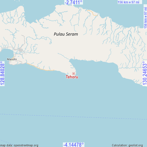
Tehoru GPS coordinates[2]
3° 26' 35.52" South, 129° 32' 36.24" East
| Map corner | latitude | longitude |
|---|---|---|
| Upper-left | -2.7411°, | 128.84028° |
| Center: | -3.4432°, | 129.5434° |
| Lower-right: | -4.14478°, | 130.24653° |
| Map W x H: | 156.1×156.1 km | = 97×97mi |
| max Lat: | 5.88969° ⇑9.6% North |
| Tehoru: | -3.4432° |
| min Lat: | ⇓90.4% South -10.934° |
| min Long | Tehoru | max Long |
| 95.1345° | 129.5434° | 140.9419° |
| W 98.7%⇐ | ⇒1.3% E |
Elevation
Elevation of Tehoru is 92 m = 302 ft, and this is 137.7 m = 452 ft below average elevation for this country.
| Max E: |
3185 m = 10449 ft | 53% |
| Avg. | 229.7 m = 754 ft | |
| Tehoru | 92 m = 302 ft | |
Min E: |
-1 m = -3 ft | 47% |
See also: Indonesia elevation on elevation.city.
Geographical zone
Tehoru is located in South Torrid zone (between Equator and Tropic of Capricorn). Distance of Equator is 382.8 km =237.9 mi to North.| Distance of | km | miles | from Tehoru |
|---|---|---|---|
| Equator | 382.8 | 237.9 | to North |
| Tropic Capricorn | 2223.1 | 1381.4 | to South |
| Antarctic Circle | 7018.3 | 4361 | to South |
| South Pole | 9624.2 | 5980.2 | to South |


Nearby cities:
15 places around Tehoru: (largest is in red/bold)
• Amahai
70.2 km =43.6 mi,  279°
279°
• Amahusu
158.1 km =98.2 mi,  258°
258°
• Ambon
153.5 km =95.4 mi, 259°
• Bula
111.9 km =69.5 mi,  70°
70°
• Kairatu
130.8 km =81.3 mi,  274°
274°
• Masohi
65.8 km =40.9 mi, 284°
• Passo
144.8 km =90 mi, 261°
• Pelau
119.6 km =74.3 mi, 265°
• Piru
155.6 km =96.7 mi,  285°
285°
• Saparua
99.9 km =62.1 mi, 261°
• Taniwel
135.4 km =84.1 mi,  299°
299°
• Tulehu
135.9 km =84.4 mi, 263°
• Wahai
72 km =44.7 mi,  359°
359°
• Waipia
76.5 km =47.5 mi, 291°
• Werinama
63.3 km =39.3 mi,  96°
96°
Sources, notices
• [Note1] Compared only with cities in Indonesia existing in our database
• [Src1] Map data: © OpenStreetMap contributors (CC-BY-SA)
• [Src2] Other city data from geonames.org with taken over terms of usage.
• [Src3] Geographical zone / Annual Mean Temperature by Robert A. Rohde @ Wikipedia
