Laci geodata
Laci (East Nusa Tenggara) is a seat of a fourth-order administrative division; located in Indonesia in Asia/Makassar (GMT+8) time zone. In our database, there are 407 cities with bigger population. Compared to other cities in Indonesia, 89.2% of cities are located further ↑North; 83% of cities are located further ←West and 59.4% of cities have lower elevation than Laci. Note1


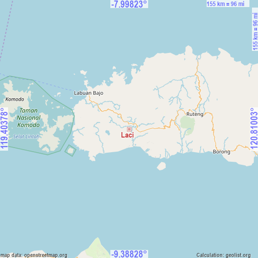
Laci GPS coordinates[2]
8° 41' 38.04" South, 120° 6' 24.84" East
| Map corner | latitude | longitude |
|---|---|---|
| Upper-left | -7.99823°, | 119.40378° |
| Center: | -8.6939°, | 120.1069° |
| Lower-right: | -9.38828°, | 120.81003° |
| Map W x H: | 154.6×154.6 km | = 96.1×96.1mi |
| max Lat: | 5.88969° ⇑89.2% North |
| Laci: | -8.6939° |
| min Lat: | ⇓10.8% South -10.934° |
| min Long | Laci | max Long |
| 95.1345° | 120.1069° | 140.9419° |
| W 83%⇐ | ⇒17% E |
Elevation
Elevation of Laci is 157 m = 515 ft, and this is 72.7 m = 239 ft below average elevation for this country.
| Max E: |
3185 m = 10449 ft | 40.6% |
| Avg. | 229.7 m = 754 ft | |
| Laci | 157 m = 515 ft | |
Min E: |
-1 m = -3 ft | 59.4% |
See also: Indonesia elevation on elevation.city.
Geographical zone
Laci is located in South Torrid zone (between Equator and Tropic of Capricorn). Distance of Equator is 966.7 km =600.7 mi to North.| Distance of | km | miles | from Laci |
|---|---|---|---|
| Equator | 966.7 | 600.7 | to North |
| Tropic Capricorn | 1639.2 | 1018.6 | to South |
| Antarctic Circle | 6434.5 | 3998.2 | to South |
| South Pole | 9040.4 | 5617.4 | to South |


Nearby cities:
15 places around Laci: (largest is in red/bold)
• Bambor
10.4 km =6.5 mi,  330°
330°
• Dahot
6.4 km =4 mi,  323°
323°
• Golondalas
14.8 km =9.2 mi, 318°
• Jeong
18.2 km =11.3 mi,  48°
48°
• Kaca
14.7 km =9.1 mi,  115°
115°
• Nangalili
9.6 km =6 mi,  163°
163°
• Ndewel
13.8 km =8.6 mi, 332°
• Nunang
11.6 km =7.2 mi,  255°
255°
• Rambang
8.4 km =5.2 mi,  307°
307°
• Ranggawatu
11.4 km =7.1 mi, 322°
• Semang
17.8 km =11.1 mi,  43°
43°
• Teongtoda
12.6 km =7.8 mi,  296°
296°
• Tondongraja
13.4 km =8.3 mi,  336°
336°
• Waepau
18 km =11.2 mi,  133°
133°
• Werang
11.7 km =7.3 mi, 295°
Sources, notices
• [Note1] Compared only with cities in Indonesia existing in our database
• [Src1] Map data: © OpenStreetMap contributors (CC-BY-SA)
• [Src2] Other city data from geonames.org with taken over terms of usage.
• [Src3] Geographical zone / Annual Mean Temperature by Robert A. Rohde @ Wikipedia
