Tigarunggu geodata
Tigarunggu (North Sumatra) is a seat of a third-order administrative division; located in Indonesia in Asia/Jakarta (GMT+7) time zone. In our database, there are 407 cities with bigger population. Compared to other cities in Indonesia, 97.9% of cities are located further ↓South; 98.1% of cities are located further →East and 99.5% of cities have lower elevation than Tigarunggu. Note1


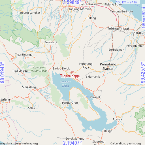
Tigarunggu GPS coordinates[2]
2° 53' 47.4" North, 98° 43' 21.36" East
| Map corner | latitude | longitude |
|---|---|---|
| Upper-left | 3.59849°, | 98.01948° |
| Center: | 2.8965°, | 98.7226° |
| Lower-right: | 2.19407°, | 99.42573° |
| Map W x H: | 156.2×156.2 km | = 97.1×97.1mi |
| max Lat: | 5.88969° ⇑2.1% North |
| Tigarunggu: | 2.8965° |
| min Lat: | ⇓97.9% South -10.934° |
| min Long | Tigarunggu | max Long |
| 95.1345° | 98.7226° | 140.9419° |
| W 1.9%⇐ | ⇒98.1% E |
Elevation
Elevation of Tigarunggu is 1313 m = 4308 ft, and this is 1083.3 m = 3554 ft above average elevation for this country.
| Max E: |
3185 m = 10449 ft | 0.5% |
| Tigarunggu | 1313 m 4308 ft | |
| Avg. | 229.7 m = 754 ft | |
Min E: |
-1 m = -3 ft | 99.5% |
See also: Indonesia elevation on elevation.city.
Geographical zone
Tigarunggu is located in North Torrid zone (between Equator and Tropic of Cancer). Distance of Equator is 322.1 km =200.1 mi to South.| Distance of | km | miles | from Tigarunggu |
|---|---|---|---|
| North Pole | 9685 | 6018 | to North |
| Arctic Circle | 7079.1 | 4398.7 | to North |
| Tropic Cancer | 2283.9 | 1419.1 | to North |
| Equator | 322.1 | 200.1 | to South |


Nearby cities:
15 places around Tigarunggu: (largest is in red/bold)
• Ambarita
26.8 km =16.7 mi,  153°
153°
• Harian
38.4 km =23.9 mi,  190°
190°
• Kabanjahe
34.3 km =21.3 mi,  311°
311°
• Pane Tongah
27.7 km =17.2 mi,  87°
87°
• Pangururan
32.2 km =20 mi, 185°
• Parapat
35.1 km =21.8 mi,  137°
137°
• Pematang Raya
15.8 km =9.8 mi,  60°
60°
• Pematangsiantar
39.1 km =24.3 mi,  79°
79°
• Saribudolok
13.3 km =8.3 mi,  290°
290°
• Sarimatondang
21.7 km =13.5 mi,  99°
99°
• Sipintuangin
11.9 km =7.4 mi, 140°
• Sondi
17.7 km =11 mi, 61°
• Tomok Bolon
31.2 km =19.4 mi, 150°
• Tongging
22.2 km =13.8 mi,  270°
270°
• Tuktuk Sonak
29.4 km =18.3 mi, 149°
Sources, notices
• [Note1] Compared only with cities in Indonesia existing in our database
• [Src1] Map data: © OpenStreetMap contributors (CC-BY-SA)
• [Src2] Other city data from geonames.org with taken over terms of usage.
• [Src3] Geographical zone / Annual Mean Temperature by Robert A. Rohde @ Wikipedia
