Saribudolok geodata
Saribudolok (North Sumatra) is a seat of a third-order administrative division; located in Indonesia in Asia/Jakarta (GMT+7) time zone. In our database, there are 407 cities with bigger population. Compared to other cities in Indonesia, 97.9% of cities are located further ↓South; 98.2% of cities are located further →East and 99.7% of cities have lower elevation than Saribudolok. Note1


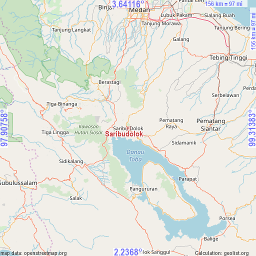
Saribudolok GPS coordinates[2]
2° 56' 21.12" North, 98° 36' 38.52" East
| Map corner | latitude | longitude |
|---|---|---|
| Upper-left | 3.64116°, | 97.90758° |
| Center: | 2.9392°, | 98.6107° |
| Lower-right: | 2.2368°, | 99.31383° |
| Map W x H: | 156.2×156.2 km | = 97.1×97.1mi |
| max Lat: | 5.88969° ⇑2.1% North |
| Saribudolok: | 2.9392° |
| min Lat: | ⇓97.9% South -10.934° |
| min Long | Saribudolok | max Long |
| 95.1345° | 98.6107° | 140.9419° |
| W 1.8%⇐ | ⇒98.2% E |
Elevation
Elevation of Saribudolok is 1411 m = 4629 ft, and this is 1181.3 m = 3876 ft above average elevation for this country.
| Max E: |
3185 m = 10449 ft | 0.3% |
| Saribudolok | 1411 m 4629 ft | |
| Avg. | 229.7 m = 754 ft | |
Min E: |
-1 m = -3 ft | 99.7% |
See also: Indonesia elevation on elevation.city.
Geographical zone
Saribudolok is located in North Torrid zone (between Equator and Tropic of Cancer). Distance of Equator is 326.8 km =203.1 mi to South.| Distance of | km | miles | from Saribudolok |
|---|---|---|---|
| North Pole | 9680.3 | 6015.1 | to North |
| Arctic Circle | 7074.4 | 4395.8 | to North |
| Tropic Cancer | 2279.1 | 1416.2 | to North |
| Equator | 326.8 | 203.1 | to South |


Nearby cities:
15 places around Saribudolok: (largest is in red/bold)
• Ambarita
37.7 km =23.4 mi,  139°
139°
• Berastagi
30.6 km =19 mi,  338°
338°
• Kabanjahe
22.3 km =13.9 mi,  323°
323°
• Pane Tongah
40.3 km =25 mi,  95°
95°
• Pangururan
38 km =23.6 mi,  165°
165°
• Pematang Raya
26.4 km =16.4 mi,  83°
83°
• Sarimatondang
34.9 km =21.7 mi, 103°
• Sidikalang
39.3 km =24.4 mi,  237°
237°
• Sipintuangin
24.4 km =15.2 mi,  125°
125°
• Sondi
28.1 km =17.5 mi, 82°
• Sumbul
32.3 km =20.1 mi,  227°
227°
• Tigarunggu
13.3 km =8.3 mi,  110°
110°
• Tomok Bolon
42.3 km =26.3 mi, 138°
• Tongging
10.7 km =6.6 mi,  245°
245°
• Tuktuk Sonak
40.7 km =25.3 mi, 137°
Sources, notices
• [Note1] Compared only with cities in Indonesia existing in our database
• [Src1] Map data: © OpenStreetMap contributors (CC-BY-SA)
• [Src2] Other city data from geonames.org with taken over terms of usage.
• [Src3] Geographical zone / Annual Mean Temperature by Robert A. Rohde @ Wikipedia
