Kabanjahe geodata
Kabanjahe (North Sumatra) is a seat of a second-order administrative division; located in Indonesia in Asia/Jakarta (GMT+7) time zone. With population of 57,159 people, there are 209 cities with bigger population in this country. Compared to other cities in Indonesia, 98.1% of cities are located further ↓South; 98.2% of cities are located further →East and 98.9% of cities have lower elevation than Kabanjahe. Note1


Kabanjahe GPS coordinates[2]
3° 6' 0.36" North, 98° 29' 26.88" East
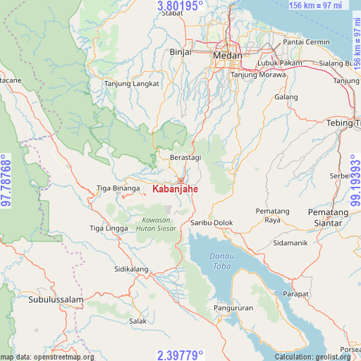
| Map corner | latitude | longitude |
|---|---|---|
| Upper-left | 3.80195°, | 97.78768° |
| Center: | 3.1001°, | 98.4908° |
| Lower-right: | 2.39779°, | 99.19393° |
| Map W x H: | 156.1×156.1 km | = 97×97mi |
| max Lat: | 5.88969° ⇑1.9% North |
| Kabanjahe: | 3.1001° |
| min Lat: | ⇓98.1% South -10.934° |
| min Long | Kabanjahe | max Long |
| 95.1345° | 98.4908° | 140.9419° |
| W 1.8%⇐ | ⇒98.2% E |
Elevation
Elevation of Kabanjahe is 1196 m = 3924 ft, and this is 966.3 m = 3170 ft above average elevation for this country.
| Max E: |
3185 m = 10449 ft | 1.1% |
| Kabanjahe | 1196 m 3924 ft | |
| Avg. | 229.7 m = 754 ft | |
Min E: |
-1 m = -3 ft | 98.9% |
See also: Kabanjahe elevation on elevation.city.
Geographical zone
Kabanjahe is located in North Torrid zone (between Equator and Tropic of Cancer). Distance of Equator is 344.7 km =214.2 mi to South.| Distance of | km | miles | from Kabanjahe |
|---|---|---|---|
| North Pole | 9662.4 | 6003.9 | to North |
| Arctic Circle | 7056.5 | 4384.7 | to North |
| Tropic Cancer | 2261.2 | 1405 | to North |
| Equator | 344.7 | 214.2 | to South |


Nearby cities:
15 places around Kabanjahe: (largest is in red/bold)
• Berastagi
10.7 km =6.6 mi,  10°
10°
• Binjai
55.6 km =34.5 mi,  359°
359°
• Deli Tua
50.1 km =31.1 mi,  25°
25°
• Medan
57.2 km =35.5 mi,  19°
19°
• Pematang Raya
42.3 km =26.3 mi,  110°
110°
• Saribudolok
22.3 km =13.9 mi,  143°
143°
• Sarimatondang
54 km =33.6 mi,  119°
119°
• Sidikalang
43.8 km =27.2 mi,  206°
206°
• Sipintuangin
46.1 km =28.6 mi,  133°
133°
• Sondi
43.5 km =27 mi, 108°
• Sukarama
54.6 km =33.9 mi,  202°
202°
• Sumbul
41.3 km =25.7 mi,  194°
194°
• Sunggal
54.7 km =34 mi, 14°
• Tigarunggu
34.3 km =21.3 mi, 131°
• Tongging
22.7 km =14.1 mi,  170°
170°
Sources, notices
• [Note1] Compared only with cities in Indonesia existing in our database
• [Src1] Map data: © OpenStreetMap contributors (CC-BY-SA)
• [Src2] Other city data from geonames.org with taken over terms of usage.
• [Src3] Geographical zone / Annual Mean Temperature by Robert A. Rohde @ Wikipedia
