Sarimatondang geodata
Sarimatondang (North Sumatra) is a seat of a third-order administrative division; located in Indonesia in Asia/Jakarta (GMT+7) time zone. In our database, there are 407 cities with bigger population. Compared to other cities in Indonesia, 97.9% of cities are located further ↓South; 97.9% of cities are located further →East and 95.5% of cities have lower elevation than Sarimatondang. Note1


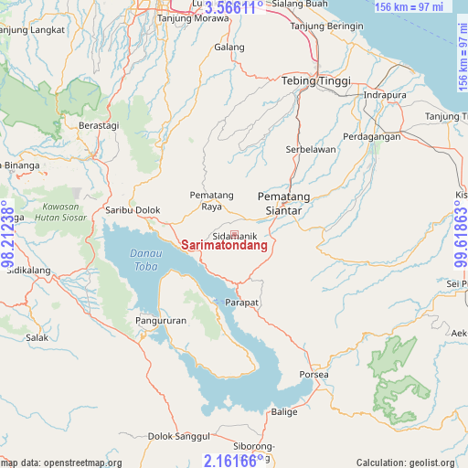
Sarimatondang GPS coordinates[2]
2° 51' 50.76" North, 98° 54' 55.8" East
| Map corner | latitude | longitude |
|---|---|---|
| Upper-left | 3.56611°, | 98.21238° |
| Center: | 2.8641°, | 98.9155° |
| Lower-right: | 2.16166°, | 99.61863° |
| Map W x H: | 156.2×156.2 km | = 97.1×97.1mi |
| max Lat: | 5.88969° ⇑2.1% North |
| Sarimatondang: | 2.8641° |
| min Lat: | ⇓97.9% South -10.934° |
| min Long | Sarimatondang | max Long |
| 95.1345° | 98.9155° | 140.9419° |
| W 2.1%⇐ | ⇒97.9% E |
Elevation
Elevation of Sarimatondang is 847 m = 2779 ft, and this is 617.3 m = 2025 ft above average elevation for this country.
| Max E: |
3185 m = 10449 ft | 4.5% |
| Sarimatondang | 847 m 2779 ft | |
| Avg. | 229.7 m = 754 ft | |
Min E: |
-1 m = -3 ft | 95.5% |
See also: Indonesia elevation on elevation.city.
Geographical zone
Sarimatondang is located in North Torrid zone (between Equator and Tropic of Cancer). Distance of Equator is 318.5 km =197.9 mi to South.| Distance of | km | miles | from Sarimatondang |
|---|---|---|---|
| North Pole | 9688.6 | 6020.2 | to North |
| Arctic Circle | 7082.7 | 4401 | to North |
| Tropic Cancer | 2287.5 | 1421.4 | to North |
| Equator | 318.5 | 197.9 | to South |


Nearby cities:
15 places around Sarimatondang: (largest is in red/bold)
• Ambarita
22.4 km =13.9 mi,  204°
204°
• Harian
44.3 km =27.5 mi,  219°
219°
• Pane Tongah
7.8 km =4.8 mi,  53°
53°
• Pangururan
37.5 km =23.3 mi, 220°
• Parapat
22.5 km =14 mi,  174°
174°
• Pekan Bahapal
39.8 km =24.7 mi, 45°
• Pematang Raya
13.6 km =8.5 mi,  326°
326°
• Pematangsiantar
20 km =12.4 mi,  58°
58°
• Saribudolok
34.9 km =21.7 mi,  283°
283°
• Sipintuangin
15 km =9.3 mi,  247°
247°
• Sondi
13.6 km =8.5 mi, 333°
• Tigarunggu
21.7 km =13.5 mi, 279°
• Tomok Bolon
24.3 km =15.1 mi,  194°
194°
• Tongging
43.7 km =27.2 mi, 275°
• Tuktuk Sonak
22.6 km =14 mi, 196°
Sources, notices
• [Note1] Compared only with cities in Indonesia existing in our database
• [Src1] Map data: © OpenStreetMap contributors (CC-BY-SA)
• [Src2] Other city data from geonames.org with taken over terms of usage.
• [Src3] Geographical zone / Annual Mean Temperature by Robert A. Rohde @ Wikipedia
