Kotakaya Dua geodata
Kotakaya Dua (East Nusa Tenggara) is a seat of a fourth-order administrative division; located in Indonesia in Asia/Makassar (GMT+8) time zone. In our database, there are 407 cities with bigger population. Compared to other cities in Indonesia, 73.9% of cities are located further ↑North; 90.8% of cities are located further ←West and 66.8% of cities have higher elevation than Kotakaya Dua. Note1


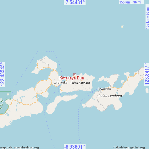
Kotakaya Dua GPS coordinates[2]
8° 14' 26.772" South, 123° 8' 18.852" East
| Map corner | latitude | longitude |
|---|---|---|
| Upper-left | -7.54431°, | 122.43545° |
| Center: | -8.24077°, | 123.13857° |
| Lower-right: | -8.93601°, | 123.8417° |
| Map W x H: | 154.7×154.7 km | = 96.1×96.1mi |
| max Lat: | 5.88969° ⇑73.9% North |
| Kotakaya Dua: | -8.24077° |
| min Lat: | ⇓26.1% South -10.934° |
| min Long | Kotakaya Dua | max Long |
| 95.1345° | 123.13857° | 140.9419° |
| W 90.8%⇐ | ⇒9.2% E |
Elevation
Elevation of Kotakaya Dua is 38 m = 125 ft, and this is 191.7 m = 629 ft below average elevation for this country.
| Max E: |
3185 m = 10449 ft | 66.8% |
| Avg. | 229.7 m = 754 ft | |
| Kotakaya Dua | 38 m = 125 ft | |
Min E: |
-1 m = -3 ft | 33.2% |
See also: Indonesia elevation on elevation.city.
Geographical zone
Kotakaya Dua is located in South Torrid zone (between Equator and Tropic of Capricorn). Distance of Equator is 916.3 km =569.4 mi to North.| Distance of | km | miles | from Kotakaya Dua |
|---|---|---|---|
| Equator | 916.3 | 569.4 | to North |
| Tropic Capricorn | 1689.6 | 1049.9 | to South |
| Antarctic Circle | 6484.9 | 4029.5 | to South |
| South Pole | 9090.8 | 5648.8 | to South |


Nearby cities:
15 places around Kotakaya Dua: (largest is in red/bold)
• Bayuwan
8.9 km =5.5 mi,  177°
177°
• Era
10 km =6.2 mi,  197°
197°
• Kanariblolong
9.4 km =5.8 mi,  235°
235°
• Ladoang
9.8 km =6.1 mi,  128°
128°
• Leter
9.2 km =5.7 mi,  192°
192°
• Lowotukan
8.6 km =5.3 mi, 132°
• Mulawato
9.5 km =5.9 mi,  172°
172°
• Papilawe
8.6 km =5.3 mi,  163°
163°
• Tanahpukang
8.5 km =5.3 mi, 171°
• Tanuwore
8 km =5 mi,  123°
123°
• Waibereno
7.3 km =4.5 mi, 176°
• Wainira
9 km =5.6 mi,  136°
136°
• Waitenepang
4.6 km =2.9 mi,  221°
221°
• Waiwadan
6.4 km =4 mi,  231°
231°
• Wewit
7.1 km =4.4 mi, 163°
Sources, notices
• [Note1] Compared only with cities in Indonesia existing in our database
• [Src1] Map data: © OpenStreetMap contributors (CC-BY-SA)
• [Src2] Other city data from geonames.org with taken over terms of usage.
• [Src3] Geographical zone / Annual Mean Temperature by Robert A. Rohde @ Wikipedia
