Binalawan geodata
Binalawan (North Kalimantan) is a seat of a third-order administrative division; located in Indonesia in Asia/Makassar (GMT+8) time zone. In our database, there are 407 cities with bigger population. Compared to other cities in Indonesia, 98.9% of cities are located further ↓South; 79.3% of cities are located further ←West and 95.5% of cities have higher elevation than Binalawan. Note1


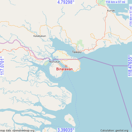
Binalawan GPS coordinates[2]
4° 5' 31.092" North, 117° 46' 23.592" East
| Map corner | latitude | longitude |
|---|---|---|
| Upper-left | 4.79298°, | 117.0701° |
| Center: | 4.09197°, | 117.77322° |
| Lower-right: | 3.39035°, | 118.47635° |
| Map W x H: | 156×156 km | = 96.9×96.9mi |
| max Lat: | 5.88969° ⇑1.1% North |
| Binalawan: | 4.09197° |
| min Lat: | ⇓98.9% South -10.934° |
| min Long | Binalawan | max Long |
| 95.1345° | 117.77322° | 140.9419° |
| W 79.3%⇐ | ⇒20.7% E |
Elevation
Elevation of Binalawan is 7 m = 23 ft, and this is 222.7 m = 731 ft below average elevation for this country.
| Max E: |
3185 m = 10449 ft | 95.5% |
| Avg. | 229.7 m = 754 ft | |
| Binalawan | 7 m = 23 ft | |
Min E: |
-1 m = -3 ft | 4.5% |
See also: Indonesia elevation on elevation.city.
Geographical zone
Binalawan is located in North Torrid zone (between Equator and Tropic of Cancer). Distance of Equator is 455 km =282.7 mi to South.| Distance of | km | miles | from Binalawan |
|---|---|---|---|
| North Pole | 9552.1 | 5935.4 | to North |
| Arctic Circle | 6946.2 | 4316.2 | to North |
| Tropic Cancer | 2150.9 | 1336.5 | to North |
| Equator | 455 | 282.7 | to South |


Nearby cities:
15 places around Binalawan: (largest is in red/bold)
• Atap
84.7 km =52.6 mi,  252°
252°
• Kerangagung
136.1 km =84.6 mi,  206°
206°
• Long Bang
168.6 km =104.8 mi, 214°
• Long Beluah
166.4 km =103.4 mi, 207°
• Malinau
139.2 km =86.5 mi, 246°
• Mensalong
119.9 km =74.5 mi, 252°
• Salinbatu
136.6 km =84.9 mi,  200°
200°
• Sebuku
82.5 km =51.3 mi,  263°
263°
• Sekatak Bengara
127.8 km =79.4 mi, 209°
• Sesayap
101.9 km =63.3 mi,  236°
236°
• Sungai Nyamuk
16.3 km =10.1 mi,  69°
69°
• Tanjung Palas
148.2 km =92.1 mi, 198°
• Tanjung Selor
146.6 km =91.1 mi, 197°
• Tarakan
88.9 km =55.2 mi,  193°
193°
• Tideng Pale
110.2 km =68.5 mi, 240°
Sources, notices
• [Note1] Compared only with cities in Indonesia existing in our database
• [Src1] Map data: © OpenStreetMap contributors (CC-BY-SA)
• [Src2] Other city data from geonames.org with taken over terms of usage.
• [Src3] Geographical zone / Annual Mean Temperature by Robert A. Rohde @ Wikipedia
