Tarakan geodata
Tarakan (North Kalimantan) is a populated place; located in Indonesia in Asia/Makassar (GMT+8) time zone. With population of 97,478 people, there are 136 cities with bigger population in this country. Compared to other cities in Indonesia, 98.2% of cities are located further ↓South; 79.2% of cities are located further ←West and 71.9% of cities have higher elevation than Tarakan. Note1


Tarakan GPS coordinates[2]
3° 18' 47.952" North, 117° 35' 29.472" East
| Map corner | latitude | longitude |
|---|---|---|
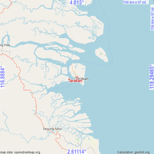
| Upper-left | 4.015°, | 116.8884° |
| Center: | 3.31332°, | 117.59152° |
| Lower-right: | 2.61114°, | 118.29465° |
| Map W x H: | 156.1×156.1 km | = 97×97mi |
| max Lat: | 5.88969° ⇑1.8% North |
| Tarakan: | 3.31332° |
| min Lat: | ⇓98.2% South -10.934° |
| min Long | Tarakan | max Long |
| 95.1345° | 117.59152° | 140.9419° |
| W 79.2%⇐ | ⇒20.8% E |
Elevation
Elevation of Tarakan is 29 m = 95 ft, and this is 200.7 m = 658 ft below average elevation for this country.
| Max E: |
3185 m = 10449 ft | 71.9% |
| Avg. | 229.7 m = 754 ft | |
| Tarakan | 29 m = 95 ft | |
Min E: |
-1 m = -3 ft | 28.1% |
See also: Tarakan elevation on elevation.city.
Geographical zone
Tarakan is located in North Torrid zone (between Equator and Tropic of Cancer). Distance of Equator is 368.4 km =228.9 mi to South.| Distance of | km | miles | from Tarakan |
|---|---|---|---|
| North Pole | 9638.7 | 5989.2 | to North |
| Arctic Circle | 7032.8 | 4370 | to North |
| Tropic Cancer | 2237.5 | 1390.3 | to North |
| Equator | 368.4 | 228.9 | to South |


Nearby cities:
15 places around Tarakan: (largest is in red/bold)
• Atap
85.5 km =53.1 mi,  314°
314°
• Binalawan
88.9 km =55.2 mi,  13°
13°
• Kerangagung
54.1 km =33.6 mi,  230°
230°
• Long Bang
92.2 km =57.3 mi,  235°
235°
• Long Beluah
83.1 km =51.6 mi,  222°
222°
• Malinau
111.7 km =69.4 mi,  285°
285°
• Mensalong
106.2 km =66 mi,  297°
297°
• Salinbatu
49.8 km =30.9 mi,  213°
213°
• Sebuku
98.4 km =61.1 mi,  321°
321°
• Sekatak Bengara
48.9 km =30.4 mi, 239°
• Sesayap
71.5 km =44.4 mi, 295°
• Sungai Nyamuk
98.9 km =61.5 mi,  20°
20°
• Tanjung Palas
60.4 km =37.5 mi, 207°
• Tanjung Selor
58.6 km =36.4 mi, 205°
• Tideng Pale
82.8 km =51.4 mi, 293°
Sources, notices
• [Note1] Compared only with cities in Indonesia existing in our database
• [Src1] Map data: © OpenStreetMap contributors (CC-BY-SA)
• [Src2] Other city data from geonames.org with taken over terms of usage.
• [Src3] Geographical zone / Annual Mean Temperature by Robert A. Rohde @ Wikipedia
