Sebuku geodata
Sebuku (North Kalimantan) is a seat of a third-order administrative division; located in Indonesia in Asia/Makassar (GMT+8) time zone. In our database, there are 407 cities with bigger population. Compared to other cities in Indonesia, 98.8% of cities are located further ↓South; 78.5% of cities are located further ←West and 99.1% of cities have higher elevation than Sebuku. Note1


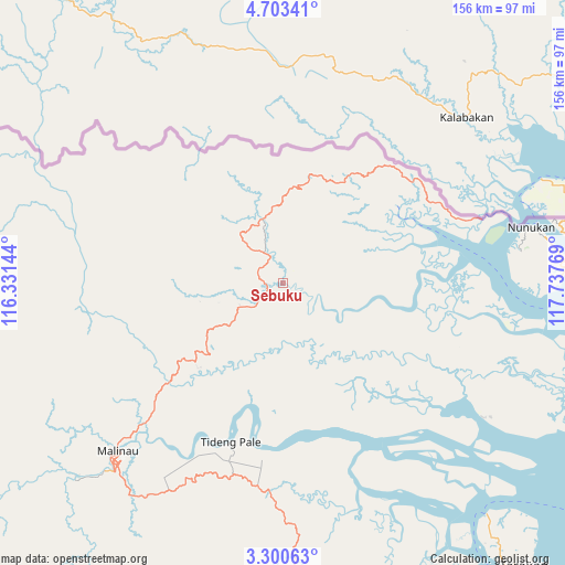
Sebuku GPS coordinates[2]
4° 0' 8.352" North, 117° 2' 4.416" East
| Map corner | latitude | longitude |
|---|---|---|
| Upper-left | 4.70341°, | 116.33144° |
| Center: | 4.00232°, | 117.03456° |
| Lower-right: | 3.30063°, | 117.73769° |
| Map W x H: | 156×156 km | = 96.9×96.9mi |
| max Lat: | 5.88969° ⇑1.2% North |
| Sebuku: | 4.00232° |
| min Lat: | ⇓98.8% South -10.934° |
| min Long | Sebuku | max Long |
| 95.1345° | 117.03456° | 140.9419° |
| W 78.5%⇐ | ⇒21.5% E |
Elevation
Elevation of Sebuku is 4 m = 13 ft, and this is 225.7 m = 740 ft below average elevation for this country.
| Max E: |
3185 m = 10449 ft | 99.1% |
| Avg. | 229.7 m = 754 ft | |
| Sebuku | 4 m = 13 ft | |
Min E: |
-1 m = -3 ft | 0.9% |
See also: Indonesia elevation on elevation.city.
Geographical zone
Sebuku is located in North Torrid zone (between Equator and Tropic of Cancer). Distance of Equator is 445 km =276.5 mi to South.| Distance of | km | miles | from Sebuku |
|---|---|---|---|
| North Pole | 9562 | 5941.5 | to North |
| Arctic Circle | 6956.2 | 4322.4 | to North |
| Tropic Cancer | 2160.9 | 1342.7 | to North |
| Equator | 445 | 276.5 | to South |


Nearby cities:
15 places around Sebuku: (largest is in red/bold)
• Atap
16.2 km =10.1 mi,  175°
175°
• Binalawan
82.5 km =51.3 mi,  83°
83°
• Kayan Hulu
131 km =81.4 mi,  261°
261°
• Kerangagung
113.1 km =70.3 mi,  169°
169°
• Long Bang
129.2 km =80.3 mi,  186°
186°
• Long Loreh
111.9 km =69.5 mi,  214°
214°
• Malinau
64.7 km =40.2 mi,  224°
224°
• Mensalong
42 km =26.1 mi,  229°
229°
• Mentarang
105.8 km =65.7 mi,  245°
245°
• Salinbatu
122.9 km =76.4 mi,  163°
163°
• Sekatak Bengara
103.6 km =64.4 mi, 168°
• Sesayap
46.5 km =28.9 mi, 183°
• Sungai Nyamuk
98.5 km =61.2 mi, 80°
• Tarakan
98.4 km =61.1 mi,  141°
141°
• Tideng Pale
46.1 km =28.6 mi,  197°
197°
Sources, notices
• [Note1] Compared only with cities in Indonesia existing in our database
• [Src1] Map data: © OpenStreetMap contributors (CC-BY-SA)
• [Src2] Other city data from geonames.org with taken over terms of usage.
• [Src3] Geographical zone / Annual Mean Temperature by Robert A. Rohde @ Wikipedia
