Sungaiboh geodata
Sungaiboh (North Kalimantan) is a seat of a third-order administrative division; located in Indonesia in Asia/Makassar (GMT+8) time zone. In our database, there are 407 cities with bigger population. Compared to other cities in Indonesia, 96.8% of cities are located further ↓South; 72.9% of cities are located further ←West and 89.6% of cities have lower elevation than Sungaiboh. Note1


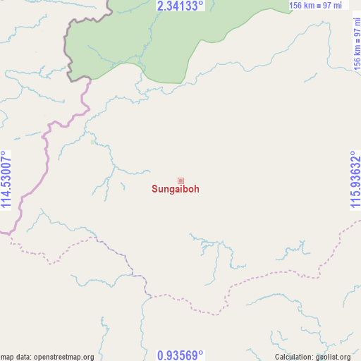
Sungaiboh GPS coordinates[2]
1° 38' 19.068" North, 115° 13' 59.484" East
| Map corner | latitude | longitude |
|---|---|---|
| Upper-left | 2.34133°, | 114.53007° |
| Center: | 1.63863°, | 115.23319° |
| Lower-right: | 0.93569°, | 115.93632° |
| Map W x H: | 156.3×156.3 km | = 97.1×97.1mi |
| max Lat: | 5.88969° ⇑3.2% North |
| Sungaiboh: | 1.63863° |
| min Lat: | ⇓96.8% South -10.934° |
| min Long | Sungaiboh | max Long |
| 95.1345° | 115.23319° | 140.9419° |
| W 72.9%⇐ | ⇒27.1% E |
Elevation
Elevation of Sungaiboh is 628 m = 2060 ft, and this is 398.3 m = 1307 ft above average elevation for this country.
| Max E: |
3185 m = 10449 ft | 10.4% |
| Sungaiboh | 628 m 2060 ft | |
| Avg. | 229.7 m = 754 ft | |
Min E: |
-1 m = -3 ft | 89.6% |
See also: Indonesia elevation on elevation.city.
Geographical zone
Sungaiboh is located in North Torrid zone (between Equator and Tropic of Cancer). Distance of Equator is 182.2 km =113.2 mi to South.| Distance of | km | miles | from Sungaiboh |
|---|---|---|---|
| North Pole | 9824.9 | 6104.9 | to North |
| Arctic Circle | 7219 | 4485.7 | to North |
| Tropic Cancer | 2423.7 | 1506 | to North |
| Equator | 182.2 | 113.2 | to South |


Nearby cities:
15 places around Sungaiboh: (largest is in red/bold)
• Data Dian
42.1 km =26.2 mi,  3°
3°
• Kayan Hulu
253.2 km =157.3 mi,  16°
16°
• Kerangagung
267.5 km =166.2 mi,  55°
55°
• Long Bang
229.3 km =142.5 mi,  54°
54°
• Long Beluah
241 km =149.8 mi, 58°
• Long Layu
225.3 km =140 mi,  13°
13°
• Long Loreh
218.6 km =135.8 mi,  38°
38°
• Long Peso
208.3 km =129.4 mi, 55°
• Long Pujungan
122.6 km =76.2 mi,  30°
30°
• Longnawang
40.5 km =25.2 mi,  294°
294°
• Malinau
266.2 km =165.4 mi, 35°
• Mentarang
242.2 km =150.5 mi, 25°
• Puruk Cahu
257.4 km =159.9 mi,  196°
196°
• Sendawar
214.7 km =133.4 mi,  166°
166°
• Ujoh Bilang
121.1 km =75.2 mi,  179°
179°
Sources, notices
• [Note1] Compared only with cities in Indonesia existing in our database
• [Src1] Map data: © OpenStreetMap contributors (CC-BY-SA)
• [Src2] Other city data from geonames.org with taken over terms of usage.
• [Src3] Geographical zone / Annual Mean Temperature by Robert A. Rohde @ Wikipedia
