Puruk Cahu geodata
Puruk Cahu (Central Kalimantan) is a seat of a second-order administrative division; located in Indonesia in Asia/Pontianak (GMT+7) time zone. In our database, there are 407 cities with bigger population. Compared to other cities in Indonesia, 94.4% of cities are located further ↓South; 69.9% of cities are located further ←West and 57.4% of cities have higher elevation than Puruk Cahu. Note1


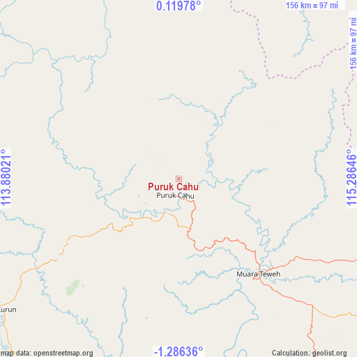
Puruk Cahu GPS coordinates[2]
0° 34' 59.988" South, 114° 34' 59.988" East
| Map corner | latitude | longitude |
|---|---|---|
| Upper-left | 0.11978°, | 113.88021° |
| Center: | -0.58333°, | 114.58333° |
| Lower-right: | -1.28636°, | 115.28646° |
| Map W x H: | 156.3×156.4 km | = 97.1×97.2mi |
| max Lat: | 5.88969° ⇑5.6% North |
| Puruk Cahu: | -0.58333° |
| min Lat: | ⇓94.4% South -10.934° |
| min Long | Puruk Cahu | max Long |
| 95.1345° | 114.58333° | 140.9419° |
| W 69.9%⇐ | ⇒30.1% E |
Elevation
Elevation of Puruk Cahu is 70 m = 230 ft, and this is 159.7 m = 524 ft below average elevation for this country.
| Max E: |
3185 m = 10449 ft | 57.4% |
| Avg. | 229.7 m = 754 ft | |
| Puruk Cahu | 70 m = 230 ft | |
Min E: |
-1 m = -3 ft | 42.6% |
See also: Indonesia elevation on elevation.city.
Geographical zone
Puruk Cahu is located in South Torrid zone (between Equator and Tropic of Capricorn). Distance of Equator is 64.9 km =40.3 mi to North.| Distance of | km | miles | from Puruk Cahu |
|---|---|---|---|
| Equator | 64.9 | 40.3 | to North |
| Tropic Capricorn | 2541.1 | 1579 | to South |
| Antarctic Circle | 7336.3 | 4558.6 | to South |
| South Pole | 9942.2 | 6177.8 | to South |


Nearby cities:
15 places around Puruk Cahu: (largest is in red/bold)
• Batusopang
202.1 km =125.6 mi,  133°
133°
• Buntok
129.7 km =80.6 mi,  167°
167°
• Haruai
189.5 km =117.7 mi,  147°
147°
• Kelua
201.8 km =125.4 mi, 153°
• Mengkalip
177.2 km =110.1 mi, 169°
• Muara Teweh
53.4 km =33.2 mi,  139°
139°
• Muarakomam
183.1 km =113.8 mi, 131°
• Muarauya
183.5 km =114 mi, 142°
• Palangkaraya
195.3 km =121.4 mi,  202°
202°
• Pasararba
203.4 km =126.4 mi,  156°
156°
• Sendawar
129.5 km =80.5 mi,  72°
72°
• Tamiang Layang
184.3 km =114.5 mi, 158°
• Tanjung
198.9 km =123.6 mi, 152°
• Tongkiling
189.7 km =117.9 mi, 204°
• Ujoh Bilang
146.2 km =90.8 mi,  30°
30°
Sources, notices
• [Note1] Compared only with cities in Indonesia existing in our database
• [Src1] Map data: © OpenStreetMap contributors (CC-BY-SA)
• [Src2] Other city data from geonames.org with taken over terms of usage.
• [Src3] Geographical zone / Annual Mean Temperature by Robert A. Rohde @ Wikipedia
