Senayang geodata
Senayang (Riau Islands) is a seat of a third-order administrative division; located in Indonesia in Asia/Jakarta (GMT+7) time zone. In our database, there are 407 cities with bigger population. Compared to other cities in Indonesia, 95.2% of cities are located further ↓South; 94.8% of cities are located further →East and 90.6% of cities have higher elevation than Senayang. Note1


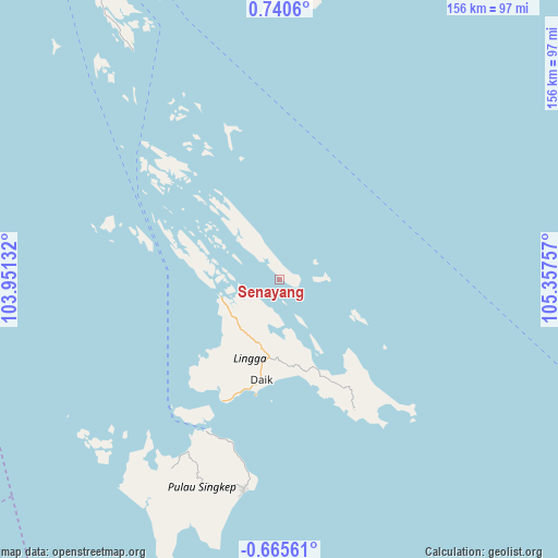
Senayang GPS coordinates[2]
0° 2' 15" North, 104° 39' 15.984" East
| Map corner | latitude | longitude |
|---|---|---|
| Upper-left | 0.7406°, | 103.95132° |
| Center: | 0.0375°, | 104.65444° |
| Lower-right: | -0.66561°, | 105.35757° |
| Map W x H: | 156.4×156.4 km | = 97.2×97.2mi |
| max Lat: | 5.88969° ⇑4.8% North |
| Senayang: | 0.0375° |
| min Lat: | ⇓95.2% South -10.934° |
| min Long | Senayang | max Long |
| 95.1345° | 104.65444° | 140.9419° |
| W 5.2%⇐ | ⇒94.8% E |
Elevation
Elevation of Senayang is 10 m = 33 ft, and this is 219.7 m = 721 ft below average elevation for this country.
| Max E: |
3185 m = 10449 ft | 90.6% |
| Avg. | 229.7 m = 754 ft | |
| Senayang | 10 m = 33 ft | |
Min E: |
-1 m = -3 ft | 9.4% |
See also: Indonesia elevation on elevation.city.
Geographical zone
Senayang is located in North Torrid zone (between Equator and Tropic of Cancer). Distance of Equator is 4.2 km =2.6 mi to South.| Distance of | km | miles | from Senayang |
|---|---|---|---|
| North Pole | 10002.9 | 6215.5 | to North |
| Arctic Circle | 7397 | 4596.3 | to North |
| Tropic Cancer | 2601.7 | 1616.6 | to North |
| Equator | 4.2 | 2.6 | to South |


Nearby cities:
15 places around Senayang: (largest is in red/bold)
• Bandar Seri Bentan
114.7 km =71.3 mi,  350°
350°
• Batam
142.1 km =88.3 mi,  330°
330°
• Belakangpadang
149.9 km =93.1 mi, 325°
• Daik Lingga
28.3 km =17.6 mi,  188°
188°
• Khairiahmandah
128.6 km =79.9 mi,  269°
269°
• Kijang
95.9 km =59.6 mi,  358°
358°
• Moro
132 km =82 mi,  307°
307°
• Nipah Panjang
133.9 km =83.2 mi,  202°
202°
• Pancur Biru Lestari II
129 km =80.2 mi, 328°
• Sapat
154.8 km =96.2 mi,  254°
254°
• Sekupang
145.7 km =90.5 mi, 326°
• Tanjung Pinang
100.2 km =62.3 mi, 347°
• Tanjungbatu
149.5 km =92.9 mi,  297°
297°
• Teluk Pinang
146.1 km =90.8 mi,  260°
260°
• Urung
154.4 km =95.9 mi, 302°
Sources, notices
• [Note1] Compared only with cities in Indonesia existing in our database
• [Src1] Map data: © OpenStreetMap contributors (CC-BY-SA)
• [Src2] Other city data from geonames.org with taken over terms of usage.
• [Src3] Geographical zone / Annual Mean Temperature by Robert A. Rohde @ Wikipedia
