Sugapa geodata
Sugapa (Papua) is a seat of a second-order administrative division; located in Indonesia in Asia/Jayapura (GMT+9) time zone. In our database, there are 407 cities with bigger population. Compared to other cities in Indonesia, 89.9% of cities are located further ↓South; 99.5% of cities are located further ←West and 99.9% of cities have lower elevation than Sugapa. Note1


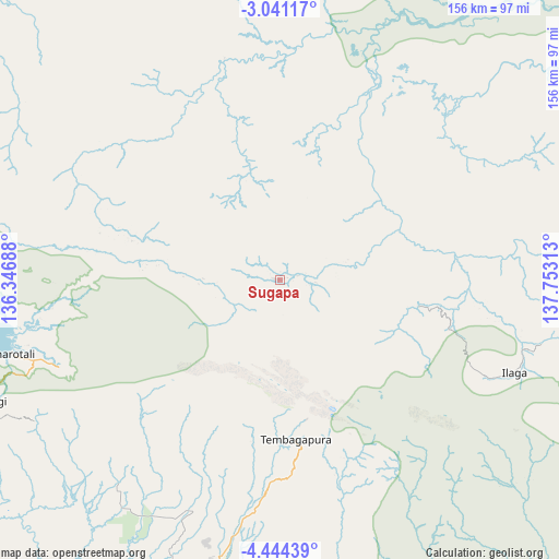
Sugapa GPS coordinates[2]
3° 44' 35.016" South, 137° 3' 0" East
| Map corner | latitude | longitude |
|---|---|---|
| Upper-left | -3.04117°, | 136.34688° |
| Center: | -3.74306°, | 137.05° |
| Lower-right: | -4.44439°, | 137.75313° |
| Map W x H: | 156×156 km | = 96.9×96.9mi |
| max Lat: | 5.88969° ⇑10.1% North |
| Sugapa: | -3.74306° |
| min Lat: | ⇓89.9% South -10.934° |
| min Long | Sugapa | max Long |
| 95.1345° | 137.05° | 140.9419° |
| W 99.5%⇐ | ⇒0.5% E |
Elevation
Elevation of Sugapa is 2144 m = 7034 ft, and this is 1914.3 m = 6281 ft above average elevation for this country.
| Max E: |
3185 m = 10449 ft | 0.099999999999994% |
| Sugapa | 2144 m 7034 ft | |
| Avg. | 229.7 m = 754 ft | |
Min E: |
-1 m = -3 ft | 99.9% |
See also: Indonesia elevation on elevation.city.
Geographical zone
Sugapa is located in South Torrid zone (between Equator and Tropic of Capricorn). Distance of Equator is 416.2 km =258.6 mi to North.| Distance of | km | miles | from Sugapa |
|---|---|---|---|
| Equator | 416.2 | 258.6 | to North |
| Tropic Capricorn | 2189.7 | 1360.6 | to South |
| Antarctic Circle | 6985 | 4340.3 | to South |
| South Pole | 9590.9 | 5959.5 | to South |


Nearby cities:
15 places around Sugapa: (largest is in red/bold)
• Beoga
16.8 km =10.4 mi,  129°
129°
• Bilogai
42.4 km =26.3 mi,  273°
273°
• Bomomani
141.3 km =87.8 mi,  255°
255°
• Enarotali
77.6 km =48.2 mi,  254°
254°
• Homeyo
65.1 km =40.5 mi,  277°
277°
• Ilaga
45.1 km =28 mi,  120°
120°
• Kigamani
125.1 km =77.7 mi, 258°
• Kumopa
60.6 km =37.7 mi, 261°
• Mapurujaya
106.5 km =66.2 mi,  193°
193°
• Moanemani
107.1 km =66.5 mi, 256°
• Mulia
103.8 km =64.5 mi,  88°
88°
• Obano
93.7 km =58.2 mi, 257°
• Tigi
90.4 km =56.2 mi, 254°
• Uta
144.3 km =89.7 mi,  231°
231°
• Waghete
92.1 km =57.2 mi, 249°
Sources, notices
• [Note1] Compared only with cities in Indonesia existing in our database
• [Src1] Map data: © OpenStreetMap contributors (CC-BY-SA)
• [Src2] Other city data from geonames.org with taken over terms of usage.
• [Src3] Geographical zone / Annual Mean Temperature by Robert A. Rohde @ Wikipedia
