Buranga geodata
Buranga (Southeast Sulawesi) is a seat of a second-order administrative division; located in Indonesia in Asia/Makassar (GMT+8) time zone. In our database, there are 407 cities with bigger population. Compared to other cities in Indonesia, 88.8% of cities are located further ↓South; 90.1% of cities are located further ←West and 59.6% of cities have higher elevation than Buranga. Note1


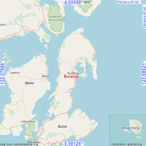
Buranga GPS coordinates[2]
4° 48' 3.528" South, 122° 58' 59.088" East
| Map corner | latitude | longitude |
|---|---|---|
| Upper-left | -4.09998°, | 122.27996° |
| Center: | -4.80098°, | 122.98308° |
| Lower-right: | -5.50126°, | 123.68621° |
| Map W x H: | 155.8×155.8 km | = 96.8×96.8mi |
| max Lat: | 5.88969° ⇑11.2% North |
| Buranga: | -4.80098° |
| min Lat: | ⇓88.8% South -10.934° |
| min Long | Buranga | max Long |
| 95.1345° | 122.98308° | 140.9419° |
| W 90.1%⇐ | ⇒9.9% E |
Elevation
Elevation of Buranga is 61 m = 200 ft, and this is 168.7 m = 553 ft below average elevation for this country.
| Max E: |
3185 m = 10449 ft | 59.6% |
| Avg. | 229.7 m = 754 ft | |
| Buranga | 61 m = 200 ft | |
Min E: |
-1 m = -3 ft | 40.4% |
See also: Indonesia elevation on elevation.city.
Geographical zone
Buranga is located in South Torrid zone (between Equator and Tropic of Capricorn). Distance of Equator is 533.8 km =331.7 mi to North.| Distance of | km | miles | from Buranga |
|---|---|---|---|
| Equator | 533.8 | 331.7 | to North |
| Tropic Capricorn | 2072.1 | 1287.5 | to South |
| Antarctic Circle | 6867.4 | 4267.2 | to South |
| South Pole | 9473.2 | 5886.4 | to South |


Nearby cities:
15 places around Buranga: (largest is in red/bold)
• Andoolo
96.6 km =60 mi,  303°
303°
• Batauga
97.4 km =60.5 mi,  206°
206°
• Katabu
53.7 km =33.4 mi,  254°
254°
• Kendari
105.2 km =65.4 mi,  330°
330°
• Kolaka
173.5 km =107.8 mi, 298°
• Labungkari
70.2 km =43.6 mi,  222°
222°
• Langara
86.3 km =53.6 mi,  0°
0°
• Lasehao
58.8 km =36.5 mi, 247°
• Laworo
50.8 km =31.6 mi,  272°
272°
• Munse
83.8 km =52.1 mi,  20°
20°
• Pasar Wajo
78.8 km =49 mi,  191°
191°
• Raha
29.3 km =18.2 mi,  261°
261°
• Rumbia
110.1 km =68.4 mi,  280°
280°
• Unaaha
148.2 km =92.1 mi,  315°
315°
• Wanci
84.9 km =52.8 mi,  133°
133°
Sources, notices
• [Note1] Compared only with cities in Indonesia existing in our database
• [Src1] Map data: © OpenStreetMap contributors (CC-BY-SA)
• [Src2] Other city data from geonames.org with taken over terms of usage.
• [Src3] Geographical zone / Annual Mean Temperature by Robert A. Rohde @ Wikipedia
