Munse geodata
Munse (Southeast Sulawesi) is a seat of a third-order administrative division; located in Indonesia in Asia/Makassar (GMT+8) time zone. In our database, there are 407 cities with bigger population. Compared to other cities in Indonesia, 89.3% of cities are located further ↓South; 91.4% of cities are located further ←West and 89% of cities have higher elevation than Munse. Note1


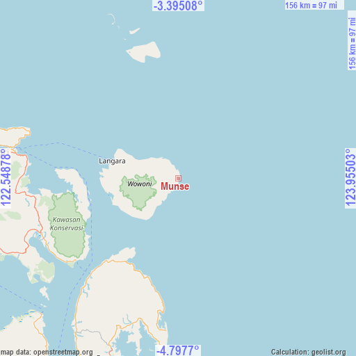
Munse GPS coordinates[2]
4° 5' 48.12" South, 123° 15' 6.84" East
| Map corner | latitude | longitude |
|---|---|---|
| Upper-left | -3.39508°, | 122.54878° |
| Center: | -4.0967°, | 123.2519° |
| Lower-right: | -4.7977°, | 123.95503° |
| Map W x H: | 156×156 km | = 96.9×96.9mi |
| max Lat: | 5.88969° ⇑10.7% North |
| Munse: | -4.0967° |
| min Lat: | ⇓89.3% South -10.934° |
| min Long | Munse | max Long |
| 95.1345° | 123.2519° | 140.9419° |
| W 91.4%⇐ | ⇒8.6% E |
Elevation
Elevation of Munse is 11 m = 36 ft, and this is 218.7 m = 718 ft below average elevation for this country.
| Max E: |
3185 m = 10449 ft | 89% |
| Avg. | 229.7 m = 754 ft | |
| Munse | 11 m = 36 ft | |
Min E: |
-1 m = -3 ft | 11% |
See also: Indonesia elevation on elevation.city.
Geographical zone
Munse is located in South Torrid zone (between Equator and Tropic of Capricorn). Distance of Equator is 455.5 km =283 mi to North.| Distance of | km | miles | from Munse |
|---|---|---|---|
| Equator | 455.5 | 283 | to North |
| Tropic Capricorn | 2150.4 | 1336.2 | to South |
| Antarctic Circle | 6945.7 | 4315.9 | to South |
| South Pole | 9551.6 | 5935.1 | to South |


Nearby cities:
15 places around Munse: (largest is in red/bold)
• Andoolo
113.8 km =70.7 mi,  256°
256°
• Asera
148.6 km =92.3 mi,  297°
297°
• Batauga
181 km =112.5 mi,  203°
203°
• Buranga
83.8 km =52.1 mi, 200°
• Katabu
123.7 km =76.9 mi,  221°
221°
• Kendari
82.8 km =51.4 mi,  279°
279°
• Labungkari
151.2 km =94 mi,  210°
210°
• Langara
30.1 km =18.7 mi,  285°
285°
• Lasehao
131.5 km =81.7 mi, 219°
• Laworo
111 km =69 mi,  226°
226°
• Pasar Wajo
162 km =100.7 mi, 196°
• Raha
101.3 km =62.9 mi, 215°
• Rumbia
150.3 km =93.4 mi,  246°
246°
• Unaaha
136.9 km =85.1 mi, 281°
• Wanci
140.5 km =87.3 mi,  166°
166°
Sources, notices
• [Note1] Compared only with cities in Indonesia existing in our database
• [Src1] Map data: © OpenStreetMap contributors (CC-BY-SA)
• [Src2] Other city data from geonames.org with taken over terms of usage.
• [Src3] Geographical zone / Annual Mean Temperature by Robert A. Rohde @ Wikipedia
