Andoolo geodata
Andoolo (Southeast Sulawesi) is a seat of a second-order administrative division; located in Indonesia in Asia/Makassar (GMT+8) time zone. In our database, there are 407 cities with bigger population. Compared to other cities in Indonesia, 89.2% of cities are located further ↓South; 88.6% of cities are located further ←West and 52% of cities have higher elevation than Andoolo. Note1


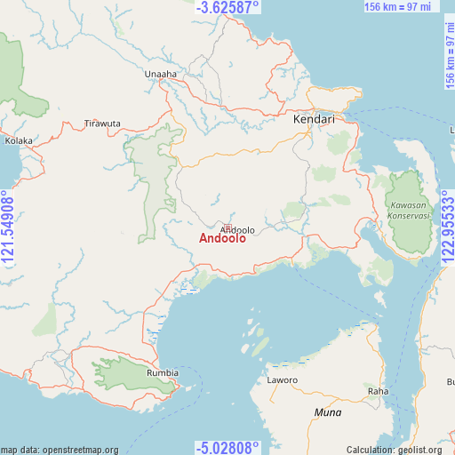
Andoolo GPS coordinates[2]
4° 19' 38.28" South, 122° 15' 7.92" East
| Map corner | latitude | longitude |
|---|---|---|
| Upper-left | -3.62587°, | 121.54908° |
| Center: | -4.3273°, | 122.2522° |
| Lower-right: | -5.02808°, | 122.95533° |
| Map W x H: | 155.9×155.9 km | = 96.9×96.9mi |
| max Lat: | 5.88969° ⇑10.8% North |
| Andoolo: | -4.3273° |
| min Lat: | ⇓89.2% South -10.934° |
| min Long | Andoolo | max Long |
| 95.1345° | 122.2522° | 140.9419° |
| W 88.6%⇐ | ⇒11.4% E |
Elevation
Elevation of Andoolo is 95 m = 312 ft, and this is 134.7 m = 442 ft below average elevation for this country.
| Max E: |
3185 m = 10449 ft | 52% |
| Avg. | 229.7 m = 754 ft | |
| Andoolo | 95 m = 312 ft | |
Min E: |
-1 m = -3 ft | 48% |
See also: Indonesia elevation on elevation.city.
Geographical zone
Andoolo is located in South Torrid zone (between Equator and Tropic of Capricorn). Distance of Equator is 481.2 km =299 mi to North.| Distance of | km | miles | from Andoolo |
|---|---|---|---|
| Equator | 481.2 | 299 | to North |
| Tropic Capricorn | 2124.8 | 1320.3 | to South |
| Antarctic Circle | 6920 | 4299.9 | to South |
| South Pole | 9525.9 | 5919.1 | to South |


Nearby cities:
15 places around Andoolo: (largest is in red/bold)
• Asera
97 km =60.3 mi,  347°
347°
• Batauga
145.3 km =90.3 mi,  164°
164°
• Buranga
96.6 km =60 mi,  123°
123°
• Katabu
73.5 km =45.7 mi, 156°
• Kendari
48.6 km =30.2 mi,  36°
36°
• Kolaka
77.6 km =48.2 mi,  292°
292°
• Labungkari
109.2 km =67.9 mi, 162°
• Langara
88.5 km =55 mi,  67°
67°
• Lasehao
80.2 km =49.8 mi, 160°
• Laworo
59 km =36.7 mi,  149°
149°
• Munse
113.8 km =70.7 mi,  76°
76°
• Pasar Wajo
145.6 km =90.5 mi, 153°
• Raha
77 km =47.8 mi,  137°
137°
• Rumbia
43.2 km =26.8 mi,  219°
219°
• Unaaha
57.6 km =35.8 mi,  336°
336°
Sources, notices
• [Note1] Compared only with cities in Indonesia existing in our database
• [Src1] Map data: © OpenStreetMap contributors (CC-BY-SA)
• [Src2] Other city data from geonames.org with taken over terms of usage.
• [Src3] Geographical zone / Annual Mean Temperature by Robert A. Rohde @ Wikipedia
