Raha geodata
Raha (Southeast Sulawesi) is a seat of a second-order administrative division; located in Indonesia in Asia/Makassar (GMT+8) time zone. In our database, there are 407 cities with bigger population. Compared to other cities in Indonesia, 88.7% of cities are located further ↓South; 89.2% of cities are located further ←West and 79.9% of cities have higher elevation than Raha. Note1


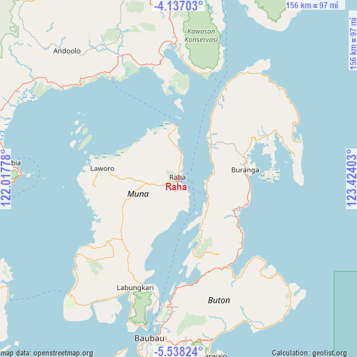
Raha GPS coordinates[2]
4° 50' 16.8" South, 122° 43' 15.24" East
| Map corner | latitude | longitude |
|---|---|---|
| Upper-left | -4.13703°, | 122.01778° |
| Center: | -4.838°, | 122.7209° |
| Lower-right: | -5.53824°, | 123.42403° |
| Map W x H: | 155.8×155.8 km | = 96.8×96.8mi |
| max Lat: | 5.88969° ⇑11.3% North |
| Raha: | -4.838° |
| min Lat: | ⇓88.7% South -10.934° |
| min Long | Raha | max Long |
| 95.1345° | 122.7209° | 140.9419° |
| W 89.2%⇐ | ⇒10.8% E |
Elevation
Elevation of Raha is 19 m = 62 ft, and this is 210.7 m = 691 ft below average elevation for this country.
| Max E: |
3185 m = 10449 ft | 79.9% |
| Avg. | 229.7 m = 754 ft | |
| Raha | 19 m = 62 ft | |
Min E: |
-1 m = -3 ft | 20.1% |
See also: Indonesia elevation on elevation.city.
Geographical zone
Raha is located in South Torrid zone (between Equator and Tropic of Capricorn). Distance of Equator is 537.9 km =334.2 mi to North.| Distance of | km | miles | from Raha |
|---|---|---|---|
| Equator | 537.9 | 334.2 | to North |
| Tropic Capricorn | 2068 | 1285 | to South |
| Antarctic Circle | 6863.2 | 4264.6 | to South |
| South Pole | 9469.1 | 5883.8 | to South |


Nearby cities:
15 places around Raha: (largest is in red/bold)
• Andoolo
77 km =47.8 mi,  317°
317°
• Batauga
84.5 km =52.5 mi,  189°
189°
• Buranga
29.3 km =18.2 mi,  81°
81°
• Katabu
25 km =15.5 mi,  244°
244°
• Kendari
98.3 km =61.1 mi,  346°
346°
• Kolaka
150.9 km =93.8 mi,  304°
304°
• Labungkari
50.9 km =31.6 mi,  201°
201°
• Langara
95.2 km =59.2 mi,  18°
18°
• Lasehao
31.3 km =19.4 mi,  233°
233°
• Laworo
22.6 km =14 mi,  285°
285°
• Munse
101.3 km =62.9 mi,  35°
35°
• Pasar Wajo
74.4 km =46.2 mi,  169°
169°
• Rumbia
82.7 km =51.4 mi, 286°
• Unaaha
132.8 km =82.5 mi,  325°
325°
• Wanci
105.7 km =65.7 mi,  120°
120°
Sources, notices
• [Note1] Compared only with cities in Indonesia existing in our database
• [Src1] Map data: © OpenStreetMap contributors (CC-BY-SA)
• [Src2] Other city data from geonames.org with taken over terms of usage.
• [Src3] Geographical zone / Annual Mean Temperature by Robert A. Rohde @ Wikipedia
