Katabu geodata
Katabu (Southeast Sulawesi) is a populated place; located in Indonesia in Asia/Makassar (GMT+8) time zone. With population of 42,750 people, there are 261 cities with bigger population in this country. Compared to other cities in Indonesia, 88.7% of cities are located further ↓South; 89% of cities are located further ←West and 59.1% of cities have higher elevation than Katabu. Note1


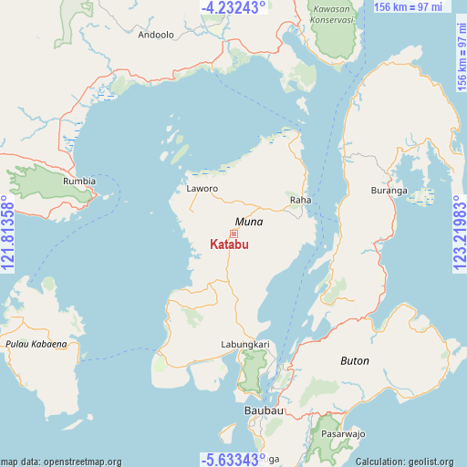
Katabu GPS coordinates[2]
4° 55' 59.88" South, 122° 31' 0.12" East
| Map corner | latitude | longitude |
|---|---|---|
| Upper-left | -4.23243°, | 121.81358° |
| Center: | -4.9333°, | 122.5167° |
| Lower-right: | -5.63343°, | 123.21983° |
| Map W x H: | 155.8×155.8 km | = 96.8×96.8mi |
| max Lat: | 5.88969° ⇑11.3% North |
| Katabu: | -4.9333° |
| min Lat: | ⇓88.7% South -10.934° |
| min Long | Katabu | max Long |
| 95.1345° | 122.5167° | 140.9419° |
| W 89%⇐ | ⇒11% E |
Elevation
Elevation of Katabu is 63 m = 207 ft, and this is 166.7 m = 547 ft below average elevation for this country.
| Max E: |
3185 m = 10449 ft | 59.1% |
| Avg. | 229.7 m = 754 ft | |
| Katabu | 63 m = 207 ft | |
Min E: |
-1 m = -3 ft | 40.9% |
See also: Katabu elevation on elevation.city.
Geographical zone
Katabu is located in South Torrid zone (between Equator and Tropic of Capricorn). Distance of Equator is 548.5 km =340.8 mi to North.| Distance of | km | miles | from Katabu |
|---|---|---|---|
| Equator | 548.5 | 340.8 | to North |
| Tropic Capricorn | 2057.4 | 1278.4 | to South |
| Antarctic Circle | 6852.6 | 4258 | to South |
| South Pole | 9458.5 | 5877.2 | to South |


Nearby cities:
15 places around Katabu: (largest is in red/bold)
• Andoolo
73.5 km =45.7 mi,  336°
336°
• Batauga
73.4 km =45.6 mi,  173°
173°
• Buranga
53.7 km =33.4 mi,  74°
74°
• Kendari
106.2 km =66 mi,  359°
359°
• Kolaka
140.1 km =87.1 mi,  313°
313°
• Labungkari
36.9 km =22.9 mi, 174°
• Langara
113.9 km =70.8 mi,  27°
27°
• Lasehao
8.5 km =5.3 mi,  196°
196°
• Laworo
16.7 km =10.4 mi,  3°
3°
• Munse
123.7 km =76.9 mi,  41°
41°
• Pasar Wajo
72.3 km =44.9 mi,  149°
149°
• Raha
25 km =15.5 mi,  64°
64°
• Rumbia
66.1 km =41.1 mi,  300°
300°
• Unaaha
131 km =81.4 mi, 336°
• Wanci
121.4 km =75.4 mi,  111°
111°
Sources, notices
• [Note1] Compared only with cities in Indonesia existing in our database
• [Src1] Map data: © OpenStreetMap contributors (CC-BY-SA)
• [Src2] Other city data from geonames.org with taken over terms of usage.
• [Src3] Geographical zone / Annual Mean Temperature by Robert A. Rohde @ Wikipedia
