Sei Rampah geodata
Sei Rampah (North Sumatra) is a seat of a second-order administrative division; located in Indonesia in Asia/Jakarta (GMT+7) time zone. In our database, there are 407 cities with bigger population. Compared to other cities in Indonesia, 98.3% of cities are located further ↓South; 97.8% of cities are located further →East and 95.5% of cities have higher elevation than Sei Rampah. Note1


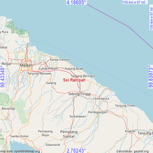
Sei Rampah GPS coordinates[2]
3° 29' 4.2" North, 99° 8' 11.76" East
| Map corner | latitude | longitude |
|---|---|---|
| Upper-left | 4.18605°, | 98.43348° |
| Center: | 3.4845°, | 99.1366° |
| Lower-right: | 2.78243°, | 99.83973° |
| Map W x H: | 156.1×156.1 km | = 97×97mi |
| max Lat: | 5.88969° ⇑1.7% North |
| Sei Rampah: | 3.4845° |
| min Lat: | ⇓98.3% South -10.934° |
| min Long | Sei Rampah | max Long |
| 95.1345° | 99.1366° | 140.9419° |
| W 2.2%⇐ | ⇒97.8% E |
Elevation
Elevation of Sei Rampah is 7 m = 23 ft, and this is 222.7 m = 731 ft below average elevation for this country.
| Max E: |
3185 m = 10449 ft | 95.5% |
| Avg. | 229.7 m = 754 ft | |
| Sei Rampah | 7 m = 23 ft | |
Min E: |
-1 m = -3 ft | 4.5% |
See also: Indonesia elevation on elevation.city.
Geographical zone
Sei Rampah is located in North Torrid zone (between Equator and Tropic of Cancer). Distance of Equator is 387.4 km =240.7 mi to South.| Distance of | km | miles | from Sei Rampah |
|---|---|---|---|
| North Pole | 9619.6 | 5977.3 | to North |
| Arctic Circle | 7013.7 | 4358.1 | to North |
| Tropic Cancer | 2218.5 | 1378.5 | to North |
| Equator | 387.4 | 240.7 | to South |


Nearby cities:
15 places around Sei Rampah: (largest is in red/bold)
• Belawan
59.8 km =37.2 mi,  302°
302°
• Deli Tua
50.3 km =31.3 mi,  272°
272°
• Labuhan Deli
58 km =36 mi, 297°
• Limapuluh
46.9 km =29.1 mi,  138°
138°
• Lubuk Pakam
30.4 km =18.9 mi,  285°
285°
• Medan
53.3 km =33.1 mi,  281°
281°
• Pane Tongah
66.9 km =41.6 mi,  195°
195°
• Pekan Bahapal
41.5 km =25.8 mi,  174°
174°
• Pematang Raya
66 km =41 mi,  209°
209°
• Pematangsiantar
58.9 km =36.6 mi,  187°
187°
• Perbaungan
22.1 km =13.7 mi, 294°
• Percut
34.1 km =21.2 mi, 297°
• Sondi
64.5 km =40.1 mi, 208°
• Sunggal
58.8 km =36.5 mi, 280°
• Tebingtinggi
17.6 km =10.9 mi, 170°
Sources, notices
• [Note1] Compared only with cities in Indonesia existing in our database
• [Src1] Map data: © OpenStreetMap contributors (CC-BY-SA)
• [Src2] Other city data from geonames.org with taken over terms of usage.
• [Src3] Geographical zone / Annual Mean Temperature by Robert A. Rohde @ Wikipedia
