Percut geodata
Percut (North Sumatra) is a populated place; located in Indonesia in Asia/Jakarta (GMT+7) time zone. With population of 311,063 people, there are 31 cities with bigger population in this country. Compared to other cities in Indonesia, 98.5% of cities are located further ↓South; 98% of cities are located further →East and 89% of cities have higher elevation than Percut. Note1


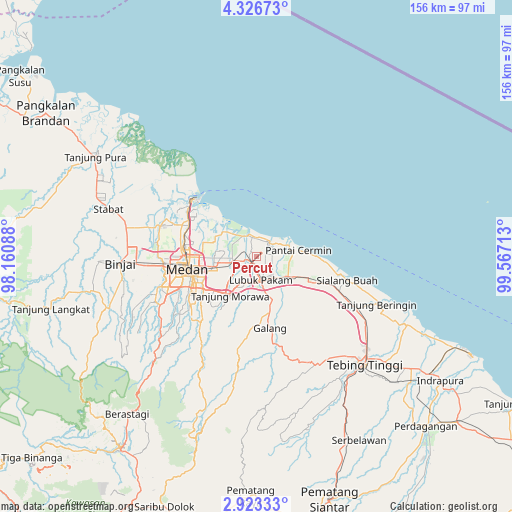
Percut GPS coordinates[2]
3° 37' 31.08" North, 98° 51' 50.4" East
| Map corner | latitude | longitude |
|---|---|---|
| Upper-left | 4.32673°, | 98.16088° |
| Center: | 3.6253°, | 98.864° |
| Lower-right: | 2.92333°, | 99.56713° |
| Map W x H: | 156×156 km | = 96.9×96.9mi |
| max Lat: | 5.88969° ⇑1.5% North |
| Percut: | 3.6253° |
| min Lat: | ⇓98.5% South -10.934° |
| min Long | Percut | max Long |
| 95.1345° | 98.864° | 140.9419° |
| W 2%⇐ | ⇒98% E |
Elevation
Elevation of Percut is 11 m = 36 ft, and this is 218.7 m = 718 ft below average elevation for this country.
| Max E: |
3185 m = 10449 ft | 89% |
| Avg. | 229.7 m = 754 ft | |
| Percut | 11 m = 36 ft | |
Min E: |
-1 m = -3 ft | 11% |
See also: Percut elevation on elevation.city.
Geographical zone
Percut is located in North Torrid zone (between Equator and Tropic of Cancer). Distance of Equator is 403.1 km =250.5 mi to South.| Distance of | km | miles | from Percut |
|---|---|---|---|
| North Pole | 9604 | 5967.6 | to North |
| Arctic Circle | 6998.1 | 4348.4 | to North |
| Tropic Cancer | 2202.8 | 1368.8 | to North |
| Equator | 403.1 | 250.5 | to South |


Nearby cities:
15 places around Percut: (largest is in red/bold)
• Belawan
26.1 km =16.2 mi,  309°
309°
• Berastagi
62 km =38.5 mi,  219°
219°
• Binjai
42.1 km =26.2 mi,  266°
266°
• Deli Tua
23.9 km =14.9 mi,  236°
236°
• Kabanjahe
71.6 km =44.5 mi, 215°
• Labuhan Deli
24 km =14.9 mi,  298°
298°
• Lubuk Pakam
7.4 km =4.6 mi,  172°
172°
• Medan
22.4 km =13.9 mi,  257°
257°
• Pekan Bahapal
66.5 km =41.3 mi,  148°
148°
• Perbaungan
12 km =7.5 mi,  122°
122°
• Sei Rampah
34.1 km =21.2 mi, 117°
• Sondi
72.5 km =45 mi,  180°
180°
• Stabat
47.5 km =29.5 mi,  284°
284°
• Sunggal
28.1 km =17.5 mi, 258°
• Tebingtinggi
46.8 km =29.1 mi,  134°
134°
Sources, notices
• [Note1] Compared only with cities in Indonesia existing in our database
• [Src1] Map data: © OpenStreetMap contributors (CC-BY-SA)
• [Src2] Other city data from geonames.org with taken over terms of usage.
• [Src3] Geographical zone / Annual Mean Temperature by Robert A. Rohde @ Wikipedia
