Limapuluh geodata
Limapuluh (North Sumatra) is a seat of a second-order administrative division; located in Indonesia in Asia/Jakarta (GMT+7) time zone. In our database, there are 407 cities with bigger population. Compared to other cities in Indonesia, 98.1% of cities are located further ↓South; 97.6% of cities are located further →East and 71.9% of cities have higher elevation than Limapuluh. Note1


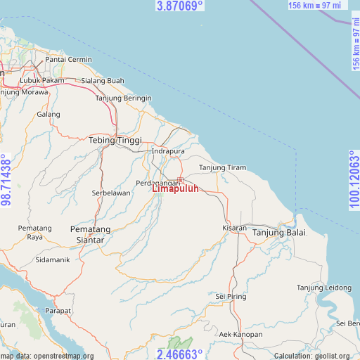
Limapuluh GPS coordinates[2]
3° 10' 8.04" North, 99° 25' 3" East
| Map corner | latitude | longitude |
|---|---|---|
| Upper-left | 3.87069°, | 98.71438° |
| Center: | 3.1689°, | 99.4175° |
| Lower-right: | 2.46663°, | 100.12063° |
| Map W x H: | 156.1×156.1 km | = 97×97mi |
| max Lat: | 5.88969° ⇑1.9% North |
| Limapuluh: | 3.1689° |
| min Lat: | ⇓98.1% South -10.934° |
| min Long | Limapuluh | max Long |
| 95.1345° | 99.4175° | 140.9419° |
| W 2.4%⇐ | ⇒97.6% E |
Elevation
Elevation of Limapuluh is 29 m = 95 ft, and this is 200.7 m = 658 ft below average elevation for this country.
| Max E: |
3185 m = 10449 ft | 71.9% |
| Avg. | 229.7 m = 754 ft | |
| Limapuluh | 29 m = 95 ft | |
Min E: |
-1 m = -3 ft | 28.1% |
See also: Indonesia elevation on elevation.city.
Geographical zone
Limapuluh is located in North Torrid zone (between Equator and Tropic of Cancer). Distance of Equator is 352.3 km =218.9 mi to South.| Distance of | km | miles | from Limapuluh |
|---|---|---|---|
| North Pole | 9654.7 | 5999.2 | to North |
| Arctic Circle | 7048.8 | 4379.9 | to North |
| Tropic Cancer | 2253.6 | 1400.3 | to North |
| Equator | 352.3 | 218.9 | to South |


Nearby cities:
15 places around Limapuluh: (largest is in red/bold)
• Aek Kanopan
71.5 km =44.4 mi,  158°
158°
• Kisaran
30.1 km =18.7 mi,  132°
132°
• Lubuk Pakam
74.4 km =46.2 mi,  305°
305°
• Pane Tongah
57.4 km =35.7 mi,  239°
239°
• Parapat
77.7 km =48.3 mi,  223°
223°
• Pekan Bahapal
27.8 km =17.3 mi,  257°
257°
• Pematang Raya
67.2 km =41.8 mi,  250°
250°
• Pematangsiantar
45.2 km =28.1 mi, 238°
• Perbaungan
67.8 km =42.1 mi, 310°
• Sarimatondang
65.2 km =40.5 mi, 238°
• Sei Rampah
46.9 km =29.1 mi,  318°
318°
• Sondi
65.4 km =40.6 mi, 250°
• Tanjungbalai
48.1 km =29.9 mi,  117°
117°
• Tebingtinggi
33.4 km =20.8 mi,  302°
302°
• Teluk Nibung
48.1 km =29.9 mi,  112°
112°
Sources, notices
• [Note1] Compared only with cities in Indonesia existing in our database
• [Src1] Map data: © OpenStreetMap contributors (CC-BY-SA)
• [Src2] Other city data from geonames.org with taken over terms of usage.
• [Src3] Geographical zone / Annual Mean Temperature by Robert A. Rohde @ Wikipedia
