Perbaungan geodata
Perbaungan (North Sumatra) is a populated place; located in Indonesia in Asia/Jakarta (GMT+7) time zone. With population of 157,174 people, there are 72 cities with bigger population in this country. Compared to other cities in Indonesia, 98.3% of cities are located further ↓South; 97.9% of cities are located further →East and 79.9% of cities have higher elevation than Perbaungan. Note1


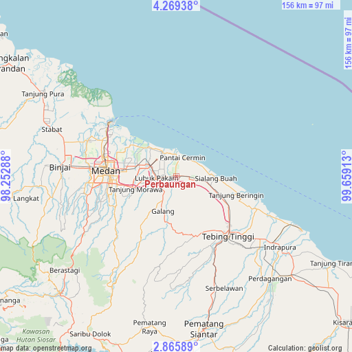
Perbaungan GPS coordinates[2]
3° 34' 4.44" North, 98° 57' 21.6" East
| Map corner | latitude | longitude |
|---|---|---|
| Upper-left | 4.26938°, | 98.25288° |
| Center: | 3.5679°, | 98.956° |
| Lower-right: | 2.86589°, | 99.65913° |
| Map W x H: | 156.1×156.1 km | = 97×97mi |
| max Lat: | 5.88969° ⇑1.7% North |
| Perbaungan: | 3.5679° |
| min Lat: | ⇓98.3% South -10.934° |
| min Long | Perbaungan | max Long |
| 95.1345° | 98.956° | 140.9419° |
| W 2.1%⇐ | ⇒97.9% E |
Elevation
Elevation of Perbaungan is 19 m = 62 ft, and this is 210.7 m = 691 ft below average elevation for this country.
| Max E: |
3185 m = 10449 ft | 79.9% |
| Avg. | 229.7 m = 754 ft | |
| Perbaungan | 19 m = 62 ft | |
Min E: |
-1 m = -3 ft | 20.1% |
See also: Perbaungan elevation on elevation.city.
Geographical zone
Perbaungan is located in North Torrid zone (between Equator and Tropic of Cancer). Distance of Equator is 396.7 km =246.5 mi to South.| Distance of | km | miles | from Perbaungan |
|---|---|---|---|
| North Pole | 9610.3 | 5971.6 | to North |
| Arctic Circle | 7004.5 | 4352.4 | to North |
| Tropic Cancer | 2209.2 | 1372.7 | to North |
| Equator | 396.7 | 246.5 | to South |


Nearby cities:
15 places around Perbaungan: (largest is in red/bold)
• Belawan
38.1 km =23.7 mi,  307°
307°
• Berastagi
64.7 km =40.2 mi,  230°
230°
• Binjai
52.3 km =32.5 mi,  273°
273°
• Deli Tua
30.9 km =19.2 mi,  257°
257°
• Labuhan Deli
36 km =22.4 mi,  299°
299°
• Limapuluh
67.8 km =42.1 mi,  130°
130°
• Lubuk Pakam
9.2 km =5.7 mi, 263°
• Medan
32.2 km =20 mi, 273°
• Pekan Bahapal
56 km =34.8 mi,  154°
154°
• Percut
12 km =7.5 mi, 302°
• Sei Rampah
22.1 km =13.7 mi,  114°
114°
• Sondi
66.9 km =41.6 mi,  189°
189°
• Stabat
59.1 km =36.7 mi,  288°
288°
• Sunggal
37.8 km =23.5 mi, 271°
• Tebingtinggi
35.1 km =21.8 mi,  139°
139°
Sources, notices
• [Note1] Compared only with cities in Indonesia existing in our database
• [Src1] Map data: © OpenStreetMap contributors (CC-BY-SA)
• [Src2] Other city data from geonames.org with taken over terms of usage.
• [Src3] Geographical zone / Annual Mean Temperature by Robert A. Rohde @ Wikipedia
