Tebingtinggi geodata
Tebingtinggi (North Sumatra) is a populated place; located in Indonesia in Asia/Jakarta (GMT+7) time zone. With population of 117,530 people, there are 111 cities with bigger population in this country. Compared to other cities in Indonesia, 98.2% of cities are located further ↓South; 97.7% of cities are located further →East and 75.5% of cities have higher elevation than Tebingtinggi. Note1


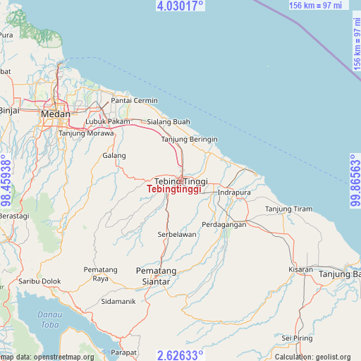
Tebingtinggi GPS coordinates[2]
3° 19' 42.6" North, 99° 9' 45" East
| Map corner | latitude | longitude |
|---|---|---|
| Upper-left | 4.03017°, | 98.45938° |
| Center: | 3.3285°, | 99.1625° |
| Lower-right: | 2.62633°, | 99.86563° |
| Map W x H: | 156.1×156.1 km | = 97×97mi |
| max Lat: | 5.88969° ⇑1.8% North |
| Tebingtinggi: | 3.3285° |
| min Lat: | ⇓98.2% South -10.934° |
| min Long | Tebingtinggi | max Long |
| 95.1345° | 99.1625° | 140.9419° |
| W 2.3%⇐ | ⇒97.7% E |
Elevation
Elevation of Tebingtinggi is 24 m = 79 ft, and this is 205.7 m = 675 ft below average elevation for this country.
| Max E: |
3185 m = 10449 ft | 75.5% |
| Avg. | 229.7 m = 754 ft | |
| Tebingtinggi | 24 m = 79 ft | |
Min E: |
-1 m = -3 ft | 24.5% |
See also: Tebingtinggi elevation on elevation.city.
Geographical zone
Tebingtinggi is located in North Torrid zone (between Equator and Tropic of Cancer). Distance of Equator is 370.1 km =230 mi to South.| Distance of | km | miles | from Tebingtinggi |
|---|---|---|---|
| North Pole | 9637 | 5988.2 | to North |
| Arctic Circle | 7031.1 | 4368.9 | to North |
| Tropic Cancer | 2235.8 | 1389.3 | to North |
| Equator | 370.1 | 230 | to South |


Nearby cities:
15 places around Tebingtinggi: (largest is in red/bold)
• Deli Tua
56.7 km =35.2 mi,  290°
290°
• Kisaran
63.2 km =39.3 mi,  127°
127°
• Limapuluh
33.4 km =20.8 mi,  122°
122°
• Lubuk Pakam
41.1 km =25.5 mi,  308°
308°
• Medan
61.9 km =38.5 mi,  297°
297°
• Pane Tongah
51.5 km =32 mi,  204°
204°
• Pekan Bahapal
24 km =14.9 mi,  177°
177°
• Pematang Raya
53.4 km =33.2 mi,  220°
220°
• Pematangsiantar
42.3 km =26.3 mi,  194°
194°
• Perbaungan
35.1 km =21.8 mi,  319°
319°
• Percut
46.8 km =29.1 mi, 314°
• Sarimatondang
58.5 km =36.4 mi,  207°
207°
• Sei Rampah
17.6 km =10.9 mi,  350°
350°
• Sondi
51.7 km =32.1 mi, 220°
• Sunggal
66.7 km =41.4 mi, 294°
Sources, notices
• [Note1] Compared only with cities in Indonesia existing in our database
• [Src1] Map data: © OpenStreetMap contributors (CC-BY-SA)
• [Src2] Other city data from geonames.org with taken over terms of usage.
• [Src3] Geographical zone / Annual Mean Temperature by Robert A. Rohde @ Wikipedia
