Langgapayung geodata
Langgapayung (North Sumatra) is a seat of a third-order administrative division; located in Indonesia in Asia/Jakarta (GMT+7) time zone. In our database, there are 407 cities with bigger population. Compared to other cities in Indonesia, 96.9% of cities are located further ↓South; 97.4% of cities are located further →East and 68% of cities have higher elevation than Langgapayung. Note1


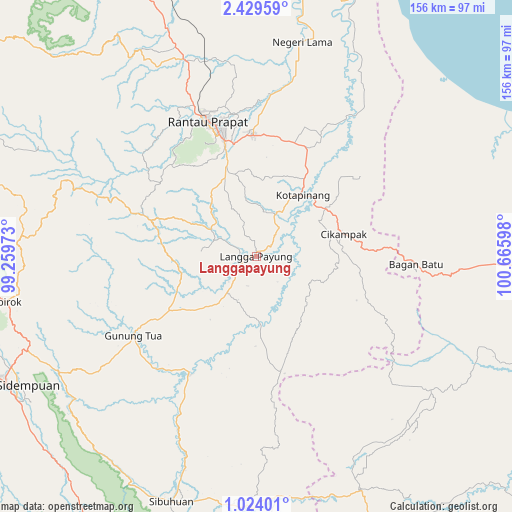
Langgapayung GPS coordinates[2]
1° 43' 36.948" North, 99° 57' 46.26" East
| Map corner | latitude | longitude |
|---|---|---|
| Upper-left | 2.42959°, | 99.25973° |
| Center: | 1.72693°, | 99.96285° |
| Lower-right: | 1.02401°, | 100.66598° |
| Map W x H: | 156.3×156.3 km | = 97.1×97.1mi |
| max Lat: | 5.88969° ⇑3.1% North |
| Langgapayung: | 1.72693° |
| min Lat: | ⇓96.9% South -10.934° |
| min Long | Langgapayung | max Long |
| 95.1345° | 99.96285° | 140.9419° |
| W 2.6%⇐ | ⇒97.4% E |
Elevation
Elevation of Langgapayung is 36 m = 118 ft, and this is 193.7 m = 635 ft below average elevation for this country.
| Max E: |
3185 m = 10449 ft | 68% |
| Avg. | 229.7 m = 754 ft | |
| Langgapayung | 36 m = 118 ft | |
Min E: |
-1 m = -3 ft | 32% |
See also: Indonesia elevation on elevation.city.
Geographical zone
Langgapayung is located in North Torrid zone (between Equator and Tropic of Cancer). Distance of Equator is 192 km =119.3 mi to South.| Distance of | km | miles | from Langgapayung |
|---|---|---|---|
| North Pole | 9815 | 6098.8 | to North |
| Arctic Circle | 7209.2 | 4479.6 | to North |
| Tropic Cancer | 2413.9 | 1499.9 | to North |
| Equator | 192 | 119.3 | to South |


Nearby cities:
15 places around Langgapayung: (largest is in red/bold)
• Bandar
43 km =26.7 mi,  326°
326°
• Binanga
40.9 km =25.4 mi,  210°
210°
• Dalududalu
78.3 km =48.7 mi,  156°
156°
• Gunung Tua
44.3 km =27.5 mi,  237°
237°
• Kota Pinang
23.2 km =14.4 mi,  38°
38°
• Panyabungan
37.8 km =23.5 mi,  307°
307°
• Pasarujungbatu
76.8 km =47.7 mi,  181°
181°
• Rantau Prapat
68 km =42.3 mi,  8°
8°
• Rantauprapat
43.9 km =27.3 mi,  340°
340°
• Sibuhuan
79.2 km =49.2 mi,  199°
199°
• Simpangbandung
79.2 km =49.2 mi,  60°
60°
• Sipagimbar
66.7 km =41.4 mi,  279°
279°
• Sipiongot
35.5 km =22.1 mi,  289°
289°
• Sipirok
77.8 km =48.3 mi,  259°
259°
• Ujungbatu
76.2 km =47.3 mi, 182°
Sources, notices
• [Note1] Compared only with cities in Indonesia existing in our database
• [Src1] Map data: © OpenStreetMap contributors (CC-BY-SA)
• [Src2] Other city data from geonames.org with taken over terms of usage.
• [Src3] Geographical zone / Annual Mean Temperature by Robert A. Rohde @ Wikipedia
