Berastagi geodata
Berastagi (North Sumatra) is a populated place; located in Indonesia in Asia/Jakarta (GMT+7) time zone. With population of 44,765 people, there are 252 cities with bigger population in this country. Compared to other cities in Indonesia, 98.1% of cities are located further ↓South; 98.2% of cities are located further →East and 99.6% of cities have lower elevation than Berastagi. Note1


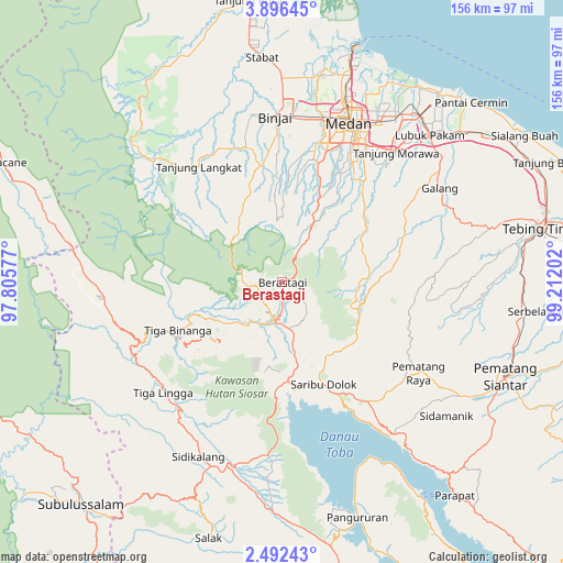
Berastagi GPS coordinates[2]
3° 11' 40.848" North, 98° 30' 32.004" East
| Map corner | latitude | longitude |
|---|---|---|
| Upper-left | 3.89645°, | 97.80577° |
| Center: | 3.19468°, | 98.50889° |
| Lower-right: | 2.49243°, | 99.21202° |
| Map W x H: | 156.1×156.1 km | = 97×97mi |
| max Lat: | 5.88969° ⇑1.9% North |
| Berastagi: | 3.19468° |
| min Lat: | ⇓98.1% South -10.934° |
| min Long | Berastagi | max Long |
| 95.1345° | 98.50889° | 140.9419° |
| W 1.8%⇐ | ⇒98.2% E |
Elevation
Elevation of Berastagi is 1402 m = 4600 ft, and this is 1172.3 m = 3846 ft above average elevation for this country.
| Max E: |
3185 m = 10449 ft | 0.40000000000001% |
| Berastagi | 1402 m 4600 ft | |
| Avg. | 229.7 m = 754 ft | |
Min E: |
-1 m = -3 ft | 99.6% |
See also: Berastagi elevation on elevation.city.
Geographical zone
Berastagi is located in North Torrid zone (between Equator and Tropic of Cancer). Distance of Equator is 355.2 km =220.7 mi to South.| Distance of | km | miles | from Berastagi |
|---|---|---|---|
| North Pole | 9651.8 | 5997.3 | to North |
| Arctic Circle | 7046 | 4378.2 | to North |
| Tropic Cancer | 2250.7 | 1398.5 | to North |
| Equator | 355.2 | 220.7 | to South |


Nearby cities:
15 places around Berastagi: (largest is in red/bold)
• Binjai
45.2 km =28.1 mi,  356°
356°
• Deli Tua
39.9 km =24.8 mi,  29°
29°
• Kabanjahe
10.7 km =6.6 mi,  190°
190°
• Lubuk Pakam
57.3 km =35.6 mi,  44°
44°
• Medan
46.6 km =29 mi,  22°
22°
• Pematang Raya
45.4 km =28.2 mi,  124°
124°
• Saribudolok
30.6 km =19 mi,  158°
158°
• Sarimatondang
58.2 km =36.2 mi,  129°
129°
• Sidikalang
54.1 km =33.6 mi,  203°
203°
• Sipintuangin
52.7 km =32.7 mi,  143°
143°
• Sondi
46.3 km =28.8 mi, 122°
• Sumbul
51.9 km =32.2 mi, 193°
• Sunggal
44.1 km =27.4 mi, 15°
• Tigarunggu
40.8 km =25.4 mi, 144°
• Tongging
33 km =20.5 mi,  177°
177°
Sources, notices
• [Note1] Compared only with cities in Indonesia existing in our database
• [Src1] Map data: © OpenStreetMap contributors (CC-BY-SA)
• [Src2] Other city data from geonames.org with taken over terms of usage.
• [Src3] Geographical zone / Annual Mean Temperature by Robert A. Rohde @ Wikipedia
