Taccipi geodata
Taccipi (South Sulawesi) is a seat of a third-order administrative division; located in Indonesia in Asia/Makassar (GMT+8) time zone. In our database, there are 407 cities with bigger population. Compared to other cities in Indonesia, 89.1% of cities are located further ↓South; 83.2% of cities are located further ←West and 60.9% of cities have lower elevation than Taccipi. Note1


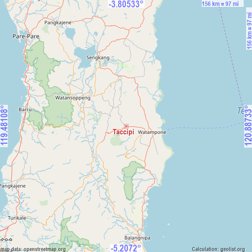
Taccipi GPS coordinates[2]
4° 30' 23.76" South, 120° 11' 3.12" East
| Map corner | latitude | longitude |
|---|---|---|
| Upper-left | -3.80533°, | 119.48108° |
| Center: | -4.5066°, | 120.1842° |
| Lower-right: | -5.2072°, | 120.88733° |
| Map W x H: | 155.9×155.9 km | = 96.9×96.9mi |
| max Lat: | 5.88969° ⇑10.9% North |
| Taccipi: | -4.5066° |
| min Lat: | ⇓89.1% South -10.934° |
| min Long | Taccipi | max Long |
| 95.1345° | 120.1842° | 140.9419° |
| W 83.2%⇐ | ⇒16.8% E |
Elevation
Elevation of Taccipi is 173 m = 568 ft, and this is 56.7 m = 186 ft below average elevation for this country.
| Max E: |
3185 m = 10449 ft | 39.1% |
| Avg. | 229.7 m = 754 ft | |
| Taccipi | 173 m = 568 ft | |
Min E: |
-1 m = -3 ft | 60.9% |
See also: Indonesia elevation on elevation.city.
Geographical zone
Taccipi is located in South Torrid zone (between Equator and Tropic of Capricorn). Distance of Equator is 501.1 km =311.4 mi to North.| Distance of | km | miles | from Taccipi |
|---|---|---|---|
| Equator | 501.1 | 311.4 | to North |
| Tropic Capricorn | 2104.8 | 1307.9 | to South |
| Antarctic Circle | 6900.1 | 4287.5 | to South |
| South Pole | 9506 | 5906.8 | to South |


Nearby cities:
15 places around Taccipi: (largest is in red/bold)
• Apala
18.6 km =11.6 mi,  129°
129°
• Bulubulu
46.4 km =28.8 mi,  166°
166°
• Camming
36 km =22.4 mi,  199°
199°
• Jalang
54.3 km =33.7 mi,  16°
16°
• Kadai
37.8 km =23.5 mi,  152°
152°
• Kotabaru
37.9 km =23.5 mi,  329°
329°
• Maroanging
35.8 km =22.2 mi,  344°
344°
• Matango
25.6 km =15.9 mi,  227°
227°
• Palakka
12 km =7.5 mi,  103°
103°
• Palattae
52.3 km =32.5 mi,  188°
188°
• Pompanua
31.5 km =19.6 mi,  352°
352°
• Sengkang
45.5 km =28.3 mi, 337°
• Tancung
53.4 km =33.2 mi, 341°
• Watampone
16.3 km =10.1 mi, 102°
• Watansoppeng
37.4 km =23.2 mi,  297°
297°
Sources, notices
• [Note1] Compared only with cities in Indonesia existing in our database
• [Src1] Map data: © OpenStreetMap contributors (CC-BY-SA)
• [Src2] Other city data from geonames.org with taken over terms of usage.
• [Src3] Geographical zone / Annual Mean Temperature by Robert A. Rohde @ Wikipedia
