Jalang geodata
Jalang (South Sulawesi) is a seat of a third-order administrative division; located in Indonesia in Asia/Makassar (GMT+8) time zone. In our database, there are 407 cities with bigger population. Compared to other cities in Indonesia, 89.4% of cities are located further ↓South; 83.7% of cities are located further ←West and 92.1% of cities have higher elevation than Jalang. Note1


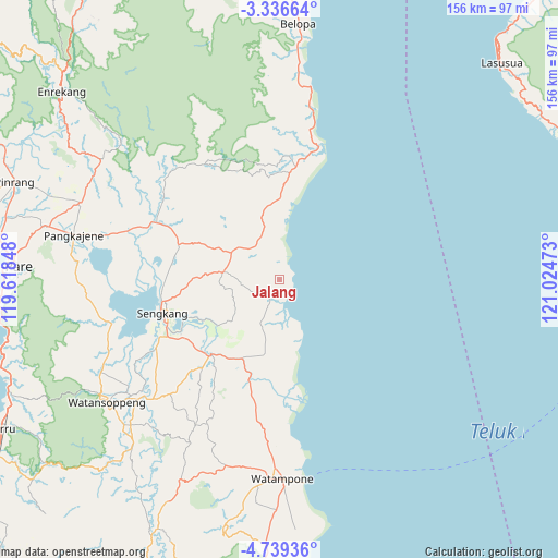
Jalang GPS coordinates[2]
4° 2' 17.88" South, 120° 19' 17.76" East
| Map corner | latitude | longitude |
|---|---|---|
| Upper-left | -3.33664°, | 119.61848° |
| Center: | -4.0383°, | 120.3216° |
| Lower-right: | -4.73936°, | 121.02473° |
| Map W x H: | 156×156 km | = 96.9×96.9mi |
| max Lat: | 5.88969° ⇑10.6% North |
| Jalang: | -4.0383° |
| min Lat: | ⇓89.4% South -10.934° |
| min Long | Jalang | max Long |
| 95.1345° | 120.3216° | 140.9419° |
| W 83.7%⇐ | ⇒16.3% E |
Elevation
Elevation of Jalang is 9 m = 30 ft, and this is 220.7 m = 724 ft below average elevation for this country.
| Max E: |
3185 m = 10449 ft | 92.1% |
| Avg. | 229.7 m = 754 ft | |
| Jalang | 9 m = 30 ft | |
Min E: |
-1 m = -3 ft | 7.9% |
See also: Indonesia elevation on elevation.city.
Geographical zone
Jalang is located in South Torrid zone (between Equator and Tropic of Capricorn). Distance of Equator is 449 km =279 mi to North.| Distance of | km | miles | from Jalang |
|---|---|---|---|
| Equator | 449 | 279 | to North |
| Tropic Capricorn | 2156.9 | 1340.2 | to South |
| Antarctic Circle | 6952.2 | 4319.9 | to South |
| South Pole | 9558 | 5939.1 | to South |


Nearby cities:
15 places around Jalang: (largest is in red/bold)
• Amparita
56.7 km =35.2 mi,  275°
275°
• Baranti
63.6 km =39.5 mi,  290°
290°
• Kotabaru
39.7 km =24.7 mi,  240°
240°
• Larompong
58.4 km =36.3 mi,  5°
5°
• Maroanging
30.3 km =18.8 mi,  234°
234°
• Palakka
54.9 km =34.1 mi,  183°
183°
• Pompanua
28.3 km =17.6 mi,  222°
222°
• Rappang
59.9 km =37.2 mi, 291°
• Sengkang
33.9 km =21.1 mi,  252°
252°
• Sidenreng
59.2 km =36.8 mi, 282°
• Siwa
39 km =24.2 mi,  15°
15°
• Taccipi
54.3 km =33.7 mi,  196°
196°
• Tancung
32.5 km =20.2 mi,  267°
267°
• Watampone
55.6 km =34.5 mi, 179°
• Watansoppeng
59.8 km =37.2 mi, 234°
Sources, notices
• [Note1] Compared only with cities in Indonesia existing in our database
• [Src1] Map data: © OpenStreetMap contributors (CC-BY-SA)
• [Src2] Other city data from geonames.org with taken over terms of usage.
• [Src3] Geographical zone / Annual Mean Temperature by Robert A. Rohde @ Wikipedia
