Palakka geodata
Palakka (South Sulawesi) is a seat of a third-order administrative division; located in Indonesia in Asia/Makassar (GMT+8) time zone. In our database, there are 407 cities with bigger population. Compared to other cities in Indonesia, 89% of cities are located further ↓South; 83.6% of cities are located further ←West and 60.3% of cities have higher elevation than Palakka. Note1


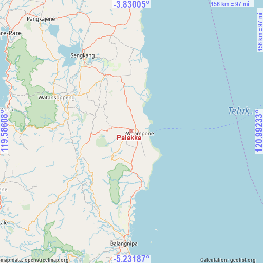
Palakka GPS coordinates[2]
4° 31' 52.68" South, 120° 17' 21.12" East
| Map corner | latitude | longitude |
|---|---|---|
| Upper-left | -3.83005°, | 119.58608° |
| Center: | -4.5313°, | 120.2892° |
| Lower-right: | -5.23187°, | 120.99233° |
| Map W x H: | 155.9×155.9 km | = 96.9×96.9mi |
| max Lat: | 5.88969° ⇑11% North |
| Palakka: | -4.5313° |
| min Lat: | ⇓89% South -10.934° |
| min Long | Palakka | max Long |
| 95.1345° | 120.2892° | 140.9419° |
| W 83.6%⇐ | ⇒16.4% E |
Elevation
Elevation of Palakka is 58 m = 190 ft, and this is 171.7 m = 563 ft below average elevation for this country.
| Max E: |
3185 m = 10449 ft | 60.3% |
| Avg. | 229.7 m = 754 ft | |
| Palakka | 58 m = 190 ft | |
Min E: |
-1 m = -3 ft | 39.7% |
See also: Indonesia elevation on elevation.city.
Geographical zone
Palakka is located in South Torrid zone (between Equator and Tropic of Capricorn). Distance of Equator is 503.8 km =313 mi to North.| Distance of | km | miles | from Palakka |
|---|---|---|---|
| Equator | 503.8 | 313 | to North |
| Tropic Capricorn | 2102.1 | 1306.2 | to South |
| Antarctic Circle | 6897.3 | 4285.8 | to South |
| South Pole | 9503.2 | 5905 | to South |


Nearby cities:
15 places around Palakka: (largest is in red/bold)
• Apala
9.4 km =5.8 mi,  163°
163°
• Bulubulu
42.4 km =26.3 mi,  181°
181°
• Camming
39.1 km =24.3 mi,  217°
217°
• Jalang
54.9 km =34.1 mi,  3°
3°
• Kadai
31.4 km =19.5 mi,  169°
169°
• Kotabaru
47 km =29.2 mi,  318°
318°
• Maroanging
42.9 km =26.7 mi,  330°
330°
• Matango
33.8 km =21 mi,  244°
244°
• Palattae
52.7 km =32.7 mi,  201°
201°
• Pompanua
37.4 km =23.2 mi,  335°
335°
• Sengkang
53.3 km =33.1 mi, 327°
• Taccipi
12 km =7.5 mi,  283°
283°
• Tancung
60.6 km =37.7 mi, 331°
• Watampone
4.4 km =2.7 mi,  100°
100°
• Watansoppeng
49.1 km =30.5 mi,  293°
293°
Sources, notices
• [Note1] Compared only with cities in Indonesia existing in our database
• [Src1] Map data: © OpenStreetMap contributors (CC-BY-SA)
• [Src2] Other city data from geonames.org with taken over terms of usage.
• [Src3] Geographical zone / Annual Mean Temperature by Robert A. Rohde @ Wikipedia
