Magelang geodata
Magelang (Central Java) is a populated place; located in Indonesia in Asia/Jakarta (GMT+7) time zone. With population of 111,461 people, there are 118 cities with bigger population in this country. Compared to other cities in Indonesia, 55.1% of cities are located further ↑North; 65.7% of cities are located further →East and 76.5% of cities have lower elevation than Magelang. Note1


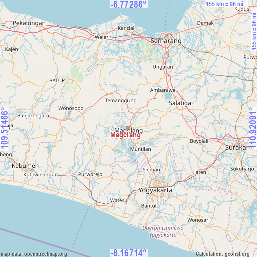
Magelang GPS coordinates[2]
7° 28' 14.016" South, 110° 13' 4.008" East
| Map corner | latitude | longitude |
|---|---|---|
| Upper-left | -6.77286°, | 109.51466° |
| Center: | -7.47056°, | 110.21778° |
| Lower-right: | -8.16714°, | 110.92091° |
| Map W x H: | 155×155 km | = 96.3×96.3mi |
| max Lat: | 5.88969° ⇑55.1% North |
| Magelang: | -7.47056° |
| min Lat: | ⇓44.9% South -10.934° |
| min Long | Magelang | max Long |
| 95.1345° | 110.21778° | 140.9419° |
| W 34.3%⇐ | ⇒65.7% E |
Elevation
Elevation of Magelang is 379 m = 1243 ft, and this is 149.3 m = 490 ft above average elevation for this country.
| Max E: |
3185 m = 10449 ft | 23.5% |
| Magelang | 379 m 1243 ft | |
| Avg. | 229.7 m = 754 ft | |
Min E: |
-1 m = -3 ft | 76.5% |
See also: Magelang elevation on elevation.city.
Geographical zone
Magelang is located in South Torrid zone (between Equator and Tropic of Capricorn). Distance of Equator is 830.6 km =516.1 mi to North.| Distance of | km | miles | from Magelang |
|---|---|---|---|
| Equator | 830.6 | 516.1 | to North |
| Tropic Capricorn | 1775.3 | 1103.1 | to South |
| Antarctic Circle | 6570.5 | 4082.7 | to South |
| South Pole | 9176.4 | 5701.9 | to South |


Nearby cities:
15 places around Magelang: (largest is in red/bold)
• Ambarawa
30.4 km =18.9 mi,  40°
40°
• Depok
40.1 km =24.9 mi,  144°
144°
• Gamping Lor
38.1 km =23.7 mi,  161°
161°
• Godean
34.3 km =21.3 mi,  165°
165°
• Gunung Kendil
25.7 km =16 mi,  53°
53°
• Melati
33.5 km =20.8 mi,  150°
150°
• Mertoyudan
5.6 km =3.5 mi, 170°
• Mungkid
13.6 km =8.5 mi,  179°
179°
• Muntilan
14.8 km =9.2 mi, 146°
• Pugeran Maguwoharjo
39.9 km =24.8 mi, 145°
• Purworejo
35.2 km =21.9 mi,  220°
220°
• Salatiga
34 km =21.1 mi,  63°
63°
• Sleman
31.2 km =19.4 mi, 150°
• Temanggung
17.1 km =10.6 mi,  350°
350°
• Wonosobo
36.9 km =22.9 mi,  289°
289°
Sources, notices
• [Note1] Compared only with cities in Indonesia existing in our database
• [Src1] Map data: © OpenStreetMap contributors (CC-BY-SA)
• [Src2] Other city data from geonames.org with taken over terms of usage.
• [Src3] Geographical zone / Annual Mean Temperature by Robert A. Rohde @ Wikipedia
