Mertoyudan geodata
Mertoyudan (Central Java) is a populated place; located in Indonesia in Asia/Jakarta (GMT+7) time zone. With population of 69,871 people, there are 179 cities with bigger population in this country. Compared to other cities in Indonesia, 56.5% of cities are located further ↑North; 65.7% of cities are located further →East and 74.4% of cities have lower elevation than Mertoyudan. Note1


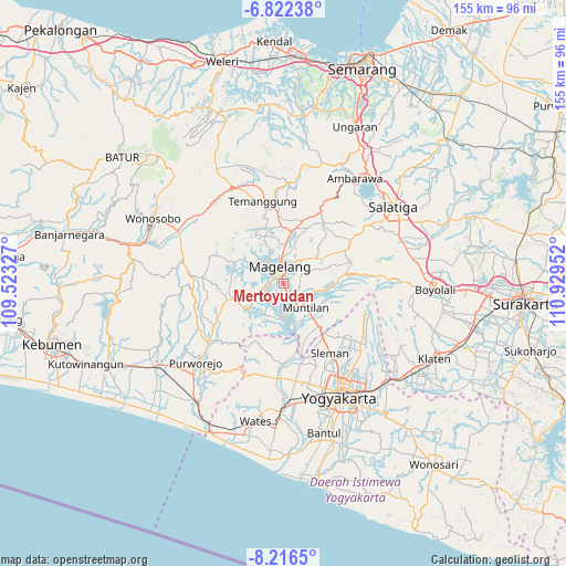
Mertoyudan GPS coordinates[2]
7° 31' 12" South, 110° 13' 35.004" East
| Map corner | latitude | longitude |
|---|---|---|
| Upper-left | -6.82238°, | 109.52327° |
| Center: | -7.52°, | 110.22639° |
| Lower-right: | -8.2165°, | 110.92952° |
| Map W x H: | 155×155 km | = 96.3×96.3mi |
| max Lat: | 5.88969° ⇑56.5% North |
| Mertoyudan: | -7.52° |
| min Lat: | ⇓43.5% South -10.934° |
| min Long | Mertoyudan | max Long |
| 95.1345° | 110.22639° | 140.9419° |
| W 34.3%⇐ | ⇒65.7% E |
Elevation
Elevation of Mertoyudan is 351 m = 1152 ft, and this is 121.3 m = 398 ft above average elevation for this country.
| Max E: |
3185 m = 10449 ft | 25.6% |
| Mertoyudan | 351 m 1152 ft | |
| Avg. | 229.7 m = 754 ft | |
Min E: |
-1 m = -3 ft | 74.4% |
See also: Mertoyudan elevation on elevation.city.
Geographical zone
Mertoyudan is located in South Torrid zone (between Equator and Tropic of Capricorn). Distance of Equator is 836.1 km =519.5 mi to North.| Distance of | km | miles | from Mertoyudan |
|---|---|---|---|
| Equator | 836.1 | 519.5 | to North |
| Tropic Capricorn | 1769.8 | 1099.7 | to South |
| Antarctic Circle | 6565 | 4079.3 | to South |
| South Pole | 9170.9 | 5698.5 | to South |


Nearby cities:
15 places around Mertoyudan: (largest is in red/bold)
• Ambarawa
34.2 km =21.3 mi,  33°
33°
• Depok
35.2 km =21.9 mi,  140°
140°
• Gamping Lor
32.6 km =20.3 mi,  160°
160°
• Godean
28.7 km =17.8 mi,  165°
165°
• Gunung Kendil
28.7 km =17.8 mi,  43°
43°
• Kasihan
36 km =22.4 mi, 161°
• Magelang
5.6 km =3.5 mi,  350°
350°
• Melati
28.3 km =17.6 mi,  146°
146°
• Mungkid
8.1 km =5 mi,  185°
185°
• Muntilan
10 km =6.2 mi,  132°
132°
• Pugeran Maguwoharjo
34.9 km =21.7 mi, 142°
• Purworejo
31.9 km =19.8 mi,  228°
228°
• Sleman
26 km =16.2 mi, 146°
• Temanggung
22.6 km =14 mi, 350°
• Yogyakarta
34.8 km =21.6 mi, 154°
Sources, notices
• [Note1] Compared only with cities in Indonesia existing in our database
• [Src1] Map data: © OpenStreetMap contributors (CC-BY-SA)
• [Src2] Other city data from geonames.org with taken over terms of usage.
• [Src3] Geographical zone / Annual Mean Temperature by Robert A. Rohde @ Wikipedia
