Kebumen geodata
Kebumen (Central Java) is a seat of a second-order administrative division; located in Indonesia in Asia/Jakarta (GMT+7) time zone. In our database, there are 407 cities with bigger population. Compared to other cities in Indonesia, 59.3% of cities are located further ↑North; 65.8% of cities are located further →East and 71.9% of cities have higher elevation than Kebumen. Note1


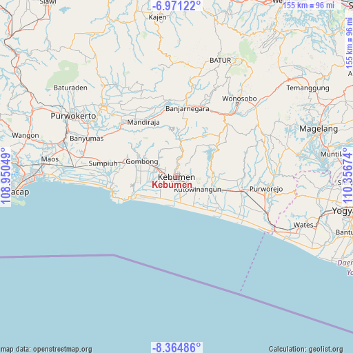
Kebumen GPS coordinates[2]
7° 40' 6.996" South, 109° 39' 12.996" East
| Map corner | latitude | longitude |
|---|---|---|
| Upper-left | -6.97122°, | 108.95049° |
| Center: | -7.66861°, | 109.65361° |
| Lower-right: | -8.36486°, | 110.35674° |
| Map W x H: | 155×155 km | = 96.3×96.3mi |
| max Lat: | 5.88969° ⇑59.3% North |
| Kebumen: | -7.66861° |
| min Lat: | ⇓40.7% South -10.934° |
| min Long | Kebumen | max Long |
| 95.1345° | 109.65361° | 140.9419° |
| W 34.2%⇐ | ⇒65.8% E |
Elevation
Elevation of Kebumen is 29 m = 95 ft, and this is 200.7 m = 658 ft below average elevation for this country.
| Max E: |
3185 m = 10449 ft | 71.9% |
| Avg. | 229.7 m = 754 ft | |
| Kebumen | 29 m = 95 ft | |
Min E: |
-1 m = -3 ft | 28.1% |
See also: Indonesia elevation on elevation.city.
Geographical zone
Kebumen is located in South Torrid zone (between Equator and Tropic of Capricorn). Distance of Equator is 852.7 km =529.8 mi to North.| Distance of | km | miles | from Kebumen |
|---|---|---|---|
| Equator | 852.7 | 529.8 | to North |
| Tropic Capricorn | 1753.2 | 1089.4 | to South |
| Antarctic Circle | 6548.5 | 4069 | to South |
| South Pole | 9154.4 | 5688.3 | to South |


Nearby cities:
15 places around Kebumen: (largest is in red/bold)
• Banjarnegara
30.7 km =19.1 mi,  8°
8°
• Banyumas
43.2 km =26.8 mi,  293°
293°
• Bayeman
48.4 km =30.1 mi,  278°
278°
• Binangun
47.1 km =29.3 mi, 288°
• Gambolempuk
47.8 km =29.7 mi, 283°
• Gombong
16.8 km =10.4 mi, 293°
• Gununglaban
47.4 km =29.5 mi, 280°
• Kroya
45.1 km =28 mi, 275°
• Kutoarjo
29.1 km =18.1 mi,  100°
100°
• Papringan
48.3 km =30 mi, 292°
• Purbalingga
44.6 km =27.7 mi,  314°
314°
• Purworejo
39.6 km =24.6 mi, 96°
• Rawaseser
45.4 km =28.2 mi, 279°
• Sokaraja
46.6 km =29 mi,  300°
300°
• Wonosobo
44.1 km =27.4 mi,  38°
38°
Sources, notices
• [Note1] Compared only with cities in Indonesia existing in our database
• [Src1] Map data: © OpenStreetMap contributors (CC-BY-SA)
• [Src2] Other city data from geonames.org with taken over terms of usage.
• [Src3] Geographical zone / Annual Mean Temperature by Robert A. Rohde @ Wikipedia
